
Topografische kaart Summit County
Interactieve kaart
Klik op de kaart om de hoogte weer te geven.
Over deze kaart
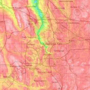
Naam: Topografische kaart Summit County, hoogte, reliëf.
Locatie: Summit County, Ohio, United States of America (40.90650 -81.68849 41.35113 -81.39169)
Gemiddelde hoogte: 327 m
Minimale hoogte: 187 m
Maximale hoogte: 405 m
Summit County is an urban county in the U.S. state of Ohio. As of the 2010 census, the population was 541,781 making it the fourth-most populous county in Ohio. Its county seat is Akron. The county was formed on March 3, 1840, from portions of Medina, Portage and Stark Counties. It was named "Summit County" because the highest elevation on the Ohio and Erie Canal is located in the county.
Andere topografische kaarten
Klik op een kaart om zijn topografie, zijn hoogte en zijn reliëf te bekijken.
Allen County
United States of America > Ohio
Allen County, Ohio, United States of America
Gemiddelde hoogte: 264 m
Kimbolton
United States of America > Ohio > Kimbolton
Kimbolton, Guernsey County, Ohio, 43749, United States of America
Gemiddelde hoogte: 275 m
Highland County
United States of America > Ohio
Highland County, Ohio, United States of America
Gemiddelde hoogte: 305 m
Ottawa County
United States of America > Ohio
Ottawa County, Ohio, United States of America
Gemiddelde hoogte: 180 m