
Topografische kaart Union
Interactieve kaart
Klik op de kaart om de hoogte weer te geven.
Over deze kaart
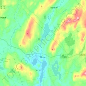
Naam: Topografische kaart Union, hoogte, reliëf.
Locatie: Union, Knox County, Maine, 04862, United States (44.17291 -69.37375 44.29456 -69.18535)
Gemiddelde hoogte: 89 m
Minimale hoogte: 5 m
Maximale hoogte: 303 m
According to the United States Census Bureau, the town has a total area of 34.49 square miles (89.33 km2), of which, 32.15 square miles (83.27 km2) of it is land and 2.34 square miles (6.06 km2) is water. Union is drained by the Medomak River, Saint George River, Pettengill Stream, Fuller Brook, Hope Brook, Little Medomak Brook and the Back River. Coggans Hill, elevation 817 feet (249 meters) above sea level, is the highest point in the town.
Andere topografische kaarten
Klik op een kaart om zijn topografie, zijn hoogte en zijn reliëf te bekijken.
Warren
United States > Maine > Knox County
Warren, Knox County, Maine, 04864, United States
Gemiddelde hoogte: 47 m
Matinicus Island
United States > Maine > Knox County > Matinicus Isle Plantation
Matinicus Island, Matinicus Isle Plantation, Knox County, Maine, United States
Gemiddelde hoogte: 5 m
Rockport
United States > Maine > Knox County
Rockport, Knox County, Maine, United States
Gemiddelde hoogte: 41 m
Camden
United States > Maine > Knox County
Camden, Knox County, Maine, 04843, United States
Gemiddelde hoogte: 63 m
South Thomaston
United States > Maine > Knox County > South Thomaston
South Thomaston, Knox County, Maine, 04858, United States
Gemiddelde hoogte: 10 m
Saint George
United States > Maine > Knox County
Saint George, Knox County, Maine, United States
Gemiddelde hoogte: 3 m
Hope
United States > Maine > Knox County
Hope, Knox County, Maine, 04847, United States
Gemiddelde hoogte: 119 m
Appleton
United States > Maine > Knox County
Appleton, Knox County, Maine, United States
Gemiddelde hoogte: 105 m
Friendship
United States > Maine > Knox County
Friendship, Knox County, Maine, 04547, United States
Gemiddelde hoogte: 10 m
Matinicus Isle Plantation
United States > Maine > Knox County
Matinicus Isle Plantation, Knox County, Maine, 04851, United States
Gemiddelde hoogte: 0 m
Owls Head
United States > Maine > Knox County
Owls Head, Knox County, Maine, 04854, United States
Gemiddelde hoogte: 4 m
Vinalhaven
United States > Maine > Knox County
Vinalhaven, Knox County, Maine, 04863, United States
Gemiddelde hoogte: 2 m
Penobscot Bay
United States > Maine > Knox County > North Haven
Penobscot Bay, North Haven, Knox County, Maine, United States
Gemiddelde hoogte: 0 m
Rockland
United States > Maine > Knox County
Rockland, Knox County, Maine, 04841, United States
Gemiddelde hoogte: 37 m