
Topografische kaart Matinicus Island
Interactieve kaart
Klik op de kaart om de hoogte weer te geven.
Matinicus Island
Matinicus Isle plantation is an archipelago located on the southeastern fringes of Penobscot Bay in the Gulf of Maine, part of the Atlantic Ocean. According to the United States Census Bureau, the plantation has a total area of 9.9 square miles (26 km2), of which 2.3 square miles (6.0 km2) is land and 7.6 square miles (20 km2) is water. Matinicus Island, the largest land mass in the archipelago, spans approximately 2 miles (3.2 km) in length and 1-mile (1.6 km) in width for an area of about 720 acres (290 ha). The elevation ranges from 0 to 100 feet (30.5 m). Matinicus Isle is located approximately 1 mile (1.6 km) north of Criehaven Isle.
Over deze kaart
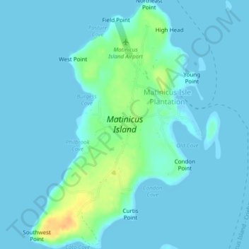
Naam: Topografische kaart Matinicus Island, hoogte, reliëf.
Gemiddelde hoogte: 5 m
Minimale hoogte: -1 m
Maximale hoogte: 33 m