Geolokaliseren

Topografische kaart Christmas Island

Klik op de kaart om de hoogte weer te geven.

Christmas Island

Steep cliffs along much of the coast rise abruptly to a central plateau. Elevation ranges from sea level to 361 m (1,184 ft) at Murray Hill. The island is mainly tropical rainforest, 63% of which is national parkland. The narrow fringing reef surrounding the island poses a maritime hazard.

Wikipedia (CC-BY-SA 3.0)

Over deze kaart

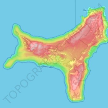
Naam: Topografische kaart Christmas Island, hoogte, reliëf.

Locatie: Christmas Island, Flying Fish Cove, Shire of Christmas Island, Christmas Island, 6798, Australia (-10.57008 105.53344 -10.41230 105.71302)

Gemiddelde hoogte: 69 m

Minimale hoogte: 0 m

Maximale hoogte: 363 m

👉 Easily get elevation data in JSON, GeoTIFF and KML formats using Elevation API
Bedankt voor het steunen van deze site ❤️
Doe een donatie

Rust jezelf uit voor je volgende avontuur:

Als Amazon-partner verdient deze site een commissie op in aanmerking komende aankopen, zonder extra kosten voor jou.

Rust jezelf uit voor je volgende avontuur:

🧤Outdoor Handschoenen - Bescherming tegen kou en wind tijdens hikes
🧭Navigatie Accessoires - Aanvullende tools voor precisie
🔭Telescopen - Bestudeer de sterrenhemel vanaf een donkere plek
📘Boeken Bergwandelen - Inspiratie en tips voor bergen
Trekking Tenten - Lichte en stevige tenten voor wandelvakanties

Als Amazon-partner verdient deze site een commissie op in aanmerking komende aankopen, zonder extra kosten voor jou.