
Topografische kaart Marshall
Interactieve kaart
Klik op de kaart om de hoogte weer te geven.
Over deze kaart
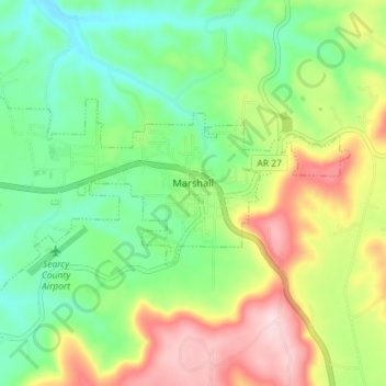
Naam: Topografische kaart Marshall, hoogte, reliëf.
Locatie: Marshall, Searcy County, Arkansas, 72650, United States (35.89277 -92.67378 35.92193 -92.60221)
Gemiddelde hoogte: 331 m
Minimale hoogte: 226 m
Maximale hoogte: 503 m
For bicycling, the Ozark Grinder Trail is a nearby gravel grinder bicycle trail covering approximately 200 miles and 13,000 feet of elevation in north central Arkansas Ozarks. The annual Arkansaw High Country Race transits through Marshall each June. This event is an approximately 1,034-mile self-supported (bikepacking) gravel cycling race with approximately 84,000 feet of total elevation.
Andere topografische kaarten
Klik op een kaart om zijn topografie, zijn hoogte en zijn reliëf te bekijken.
Lead Hill
United States > Arkansas > Searcy County
Lead Hill, Searcy County, Arkansas, United States
Gemiddelde hoogte: 286 m
Saint Joe
United States > Arkansas > Searcy County
Saint Joe, Searcy County, Arkansas, 72675, United States
Gemiddelde hoogte: 260 m
Gilbert
United States > Arkansas > Searcy County
Gilbert, Searcy County, Arkansas, 72636, United States
Gemiddelde hoogte: 216 m
Buffalo River
United States > Arkansas > Searcy County > Gilbert
Buffalo River, Gilbert, Searcy County, Arkansas, 72636, United States
Gemiddelde hoogte: 217 m
Buffalo National River
United States > Arkansas > Searcy County
Buffalo National River, Searcy County, Arkansas, 72624, United States
Gemiddelde hoogte: 444 m
Leslie
United States > Arkansas > Searcy County > Leslie > Leslie
Leslie, Searcy County, Arkansas, 72645, United States
Gemiddelde hoogte: 347 m
Cozahome
United States > Arkansas > Searcy County > Cozahome
Cozahome, Searcy County, Arkansas, United States
Gemiddelde hoogte: 307 m