
Topografische kaart Buffalo National River
Interactieve kaart
Klik op de kaart om de hoogte weer te geven.
Over deze kaart
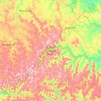
Naam: Topografische kaart Buffalo National River, hoogte, reliëf.
Gemiddelde hoogte: 444 m
Minimale hoogte: 186 m
Maximale hoogte: 775 m
Along the upper river, the gradient is steep and the water is fast, leveling and slowing as the river runs its course. The upper section has most of the whitewater rapids to be found along the river, and features dramatic karst topography including sink holes and caves, springs, and waterfalls, over 500-foot (150 m) tall sandstone and limestone bluffs, and many rock formations. At one point, a 0.65-mile (1.05 km) hike from the river up a narrow, boxed canyon leads to a 209-foot (64 m) waterfall, Hemmed-In-Hollow Falls, the highest of its kind between the Southern Appalachians and the Rockies. The river's current also gives life to well over 300 species of fish, insects, freshwater mussels, and aquatic plants.
Andere topografische kaarten
Klik op een kaart om zijn topografie, zijn hoogte en zijn reliëf te bekijken.
Lead Hill
United States > Arkansas > Searcy County
Lead Hill, Searcy County, Arkansas, United States
Gemiddelde hoogte: 286 m
Saint Joe
United States > Arkansas > Searcy County
Saint Joe, Searcy County, Arkansas, 72675, United States
Gemiddelde hoogte: 260 m
Gilbert
United States > Arkansas > Searcy County
Gilbert, Searcy County, Arkansas, 72636, United States
Gemiddelde hoogte: 216 m
Buffalo River
United States > Arkansas > Searcy County > Gilbert
Buffalo River, Gilbert, Searcy County, Arkansas, 72636, United States
Gemiddelde hoogte: 217 m
Leslie
United States > Arkansas > Searcy County > Leslie > Leslie
Leslie, Searcy County, Arkansas, 72645, United States
Gemiddelde hoogte: 347 m
Cozahome
United States > Arkansas > Searcy County > Cozahome
Cozahome, Searcy County, Arkansas, United States
Gemiddelde hoogte: 307 m
Marshall
United States > Arkansas > Searcy County
Marshall, Searcy County, Arkansas, 72650, United States
Gemiddelde hoogte: 331 m