
Doe een donatie
Rust jezelf uit voor je volgende avontuur:
Als Amazon-partner verdient deze site een commissie op in aanmerking komende aankopen, zonder extra kosten voor jou.
Topografische kaart Bodo
Klik op de kaart om de hoogte weer te geven.
Doe een donatie
Rust jezelf uit voor je volgende avontuur:
Als Amazon-partner verdient deze site een commissie op in aanmerking komende aankopen, zonder extra kosten voor jou.
Over deze kaart
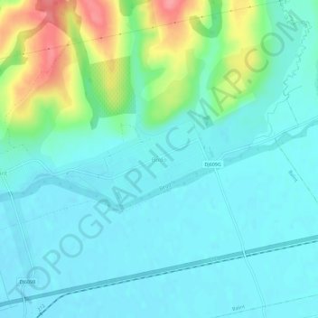
Naam: Topografische kaart Bodo, hoogte, reliëf.
Locatie: Bodo, Balinț, Timiș, 307006, Romania (45.79616 21.86516 45.83616 21.90516)
Gemiddelde hoogte: 131 m
Minimale hoogte: 112 m
Maximale hoogte: 196 m
Doe een donatie
Rust jezelf uit voor je volgende avontuur:
Als Amazon-partner verdient deze site een commissie op in aanmerking komende aankopen, zonder extra kosten voor jou.
Andere topografische kaarten
Klik op een kaart om zijn topografie, zijn hoogte en zijn reliëf te bekijken.
Timișoara
Timișoara lies at an altitude of 90 metres on the southeast edge of the Banat Plain, part of the Pannonian Plain, near the divergence of the Timiș and Bega rivers. The waters of the two rivers form a swampy and frequently flooded land. Timișoara developed on one of few places where the swamps could be…
Gemiddelde hoogte: 92 m
Doe een donatie
Rust jezelf uit voor je volgende avontuur:
Als Amazon-partner verdient deze site een commissie op in aanmerking komende aankopen, zonder extra kosten voor jou.
Sannicolau Mare
The territory is located in the Mureș Plain, which is a typical form of fluvio-lacustrine subsidence, with shallow valleys with abandoned riverbeds resulting from the regularization of watercourses and drainage, with an altitude between 80–85 m (262–279 ft). The northern part is located in the former…
Gemiddelde hoogte: 85 m
Doe een donatie
Rust jezelf uit voor je volgende avontuur:
Als Amazon-partner verdient deze site een commissie op in aanmerking komende aankopen, zonder extra kosten voor jou.
Timișoara
Timișoara lies at an altitude of 90 metres on the southeast edge of the Banat Plain, part of the Pannonian Plain, near the divergence of the Timiș and Bega rivers. The waters of the two rivers form a swampy and frequently flooded land. Timișoara developed on one of few places where the swamps could be…
Gemiddelde hoogte: 92 m
Doe een donatie
Rust jezelf uit voor je volgende avontuur:
Als Amazon-partner verdient deze site een commissie op in aanmerking komende aankopen, zonder extra kosten voor jou.
Doe een donatie
Rust jezelf uit voor je volgende avontuur:
Als Amazon-partner verdient deze site een commissie op in aanmerking komende aankopen, zonder extra kosten voor jou.
Lugoj
The territory of Lugoj belongs to the high plain of Lugoj and the hills of Lugoj. Located in the contact area of these units, the city developed on the lower terrace of the Timiș River, on both its banks. The relief unit in which Lugoj is located is the Lugoj Plain, which penetrates deep into the piedmont…
Gemiddelde hoogte: 145 m
Doe een donatie
Rust jezelf uit voor je volgende avontuur:
Als Amazon-partner verdient deze site een commissie op in aanmerking komende aankopen, zonder extra kosten voor jou.
Jimbolia
Jimbolia is located in the west of Timiș County, 39 km from Timișoara, with which it is connected by the county road 59A and the Kikinda–Jimbolia–Timișoara railway. It lies in the Banat Plain, at the contact between the Timiș Plain and the Mureș Plain. An alignment of villages marks the boundary…
Gemiddelde hoogte: 80 m
Doe een donatie
Rust jezelf uit voor je volgende avontuur:
Als Amazon-partner verdient deze site een commissie op in aanmerking komende aankopen, zonder extra kosten voor jou.
Timișoara
Timișoara lies at an altitude of 90 metres on the southeast edge of the Banat Plain, part of the Pannonian Plain, near the divergence of the Timiș and Bega rivers. The waters of the two rivers form a swampy and frequently flooded land. Timișoara developed on one of few places where the swamps could be…
Gemiddelde hoogte: 92 m