
Doe een donatie
Rust jezelf uit voor je volgende avontuur:
Als Amazon-partner verdient deze site een commissie op in aanmerking komende aankopen, zonder extra kosten voor jou.
Topografische kaart Jimbolia
Klik op de kaart om de hoogte weer te geven.
Doe een donatie
Rust jezelf uit voor je volgende avontuur:
Als Amazon-partner verdient deze site een commissie op in aanmerking komende aankopen, zonder extra kosten voor jou.
Jimbolia
Jimbolia is located in the west of Timiș County, 39 km from Timișoara, with which it is connected by the county road 59A and the Kikinda–Jimbolia–Timișoara railway. It lies in the Banat Plain, at the contact between the Timiș Plain and the Mureș Plain. An alignment of villages marks the boundary between the two relief units: Checea–Cărpiniș–Satchinez. The average altitude of the town is 82 m. It is located at the intersection of some roads that connect Romania and Serbia, being also a rail and road border point at the frontier between the two countries.
Doe een donatie
Rust jezelf uit voor je volgende avontuur:
Als Amazon-partner verdient deze site een commissie op in aanmerking komende aankopen, zonder extra kosten voor jou.
Over deze kaart
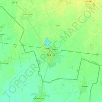
Naam: Topografische kaart Jimbolia, hoogte, reliëf.
Locatie: Jimbolia, Timiș, 305400, Romania (45.74893 20.65092 45.84548 20.86977)
Gemiddelde hoogte: 80 m
Minimale hoogte: 73 m
Maximale hoogte: 89 m
Doe een donatie
Rust jezelf uit voor je volgende avontuur:
Als Amazon-partner verdient deze site een commissie op in aanmerking komende aankopen, zonder extra kosten voor jou.
Andere topografische kaarten
Klik op een kaart om zijn topografie, zijn hoogte en zijn reliëf te bekijken.
Doe een donatie
Rust jezelf uit voor je volgende avontuur:
Als Amazon-partner verdient deze site een commissie op in aanmerking komende aankopen, zonder extra kosten voor jou.
Doe een donatie
Rust jezelf uit voor je volgende avontuur:
Als Amazon-partner verdient deze site een commissie op in aanmerking komende aankopen, zonder extra kosten voor jou.
Doe een donatie
Rust jezelf uit voor je volgende avontuur:
Als Amazon-partner verdient deze site een commissie op in aanmerking komende aankopen, zonder extra kosten voor jou.
Doe een donatie
Rust jezelf uit voor je volgende avontuur:
Als Amazon-partner verdient deze site een commissie op in aanmerking komende aankopen, zonder extra kosten voor jou.