
Topografische kaart Farmingville
Interactieve kaart
Klik op de kaart om de hoogte weer te geven.
Over deze kaart
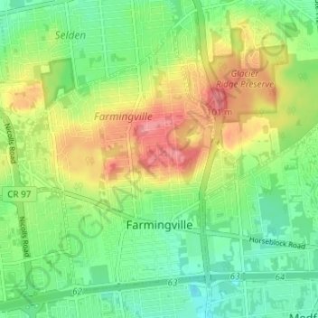
Naam: Topografische kaart Farmingville, hoogte, reliëf.
Gemiddelde hoogte: 47 m
Minimale hoogte: 16 m
Maximale hoogte: 94 m
Andere topografische kaarten
Klik op een kaart om zijn topografie, zijn hoogte en zijn reliëf te bekijken.
Saratoga County
United States of America > New York
Saratoga County, New York, United States of America
Gemiddelde hoogte: 218 m
Queens
United States of America > New York > New York
Queens, New York, United States of America
Gemiddelde hoogte: 11 m
Saint Lawrence
United States of America > New York
Saint Lawrence, New York, United States of America
Gemiddelde hoogte: 239 m
Essex County
United States of America > New York
Essex County, New York, United States of America
Gemiddelde hoogte: 418 m
Nassau County
United States of America > New York
Nassau County, New York, United States of America
Gemiddelde hoogte: 18 m
Allegany County
United States of America > New York
Allegany County, New York, United States of America
Gemiddelde hoogte: 561 m
Valley Stream
United States of America > New York > Valley Stream > Valley Stream
Valley Stream, Hempstead, Nassau County, New York, 11580, United States of America
Gemiddelde hoogte: 7 m
New York County
United States of America > New York > New York
New York County, New York, United States of America
Gemiddelde hoogte: 16 m