
Topografische kaart Essex County
Interactieve kaart
Klik op de kaart om de hoogte weer te geven.
Over deze kaart
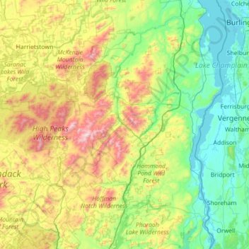
Naam: Topografische kaart Essex County, hoogte, reliëf.
Locatie: Essex County, New York, United States of America (43.74451 -74.33683 44.54861 -73.29338)
Gemiddelde hoogte: 418 m
Minimale hoogte: 25 m
Maximale hoogte: 1.607 m
Essex County is in the northeastern part of New York state, just west of Vermont along the eastern boundary of the state. The eastern boundary of Essex County is Lake Champlain, which serves as the New York – Vermont border at an elevation of just under 100 feet (30.5 m). The highest natural point in New York, Mount Marcy at 5,344 feet (1,629 m), is in the town of Keene.
Andere topografische kaarten
Klik op een kaart om zijn topografie, zijn hoogte en zijn reliëf te bekijken.
Saratoga County
United States of America > New York
Saratoga County, New York, United States of America
Gemiddelde hoogte: 218 m
Farmingville
United States of America > New York
Farmingville, Suffolk County, New York, 11738, United States of America
Gemiddelde hoogte: 47 m
Queens
United States of America > New York > New York
Queens, New York, United States of America
Gemiddelde hoogte: 11 m
Saint Lawrence
United States of America > New York
Saint Lawrence, New York, United States of America
Gemiddelde hoogte: 239 m
Nassau County
United States of America > New York
Nassau County, New York, United States of America
Gemiddelde hoogte: 18 m
Allegany County
United States of America > New York
Allegany County, New York, United States of America
Gemiddelde hoogte: 561 m
Valley Stream
United States of America > New York > Valley Stream > Valley Stream
Valley Stream, Hempstead, Nassau County, New York, 11580, United States of America
Gemiddelde hoogte: 7 m
New York County
United States of America > New York > New York
New York County, New York, United States of America
Gemiddelde hoogte: 16 m