
Doe een donatie
Rust jezelf uit voor je volgende avontuur:
Als Amazon-partner verdient deze site een commissie op in aanmerking komende aankopen, zonder extra kosten voor jou.
Topografische kaart Jiangsu
Klik op de kaart om de hoogte weer te geven.
Doe een donatie
Rust jezelf uit voor je volgende avontuur:
Als Amazon-partner verdient deze site een commissie op in aanmerking komende aankopen, zonder extra kosten voor jou.
Jiangsu
Jiangsu is flat, with plains covering 68 percent of its total area (water covers another 18 percent). Most of the province stands not more than 50 meters (160 ft) above sea level. Jiangsu also has a well-developed irrigation system, which earned it (especially the southern half) the moniker of traditional Chinese: 水鄕; simplified Chinese: 水乡 (shuǐxiāng "land of water"). The southern city of Suzhou has so many canals that it has been dubbed "Venice of the East" or the "Venice of the Orient." The Grand Canal of China cuts through Jiangsu from north to south, crossing all the east–west river systems. Jiangsu also borders the Yellow Sea. The Yangtze River, the longest river of China, cuts through the province in the south and reaches the East China Sea, which divides the region into two parts: more urban, prosperous south and more poorer, rural north, and these two parts has a tense division. Mount Huaguo, near the city of Lianyungang, is the highest point in Jiangsu, at an altitude of 625 meters (2,051 ft) above sea level. Large lakes in Jiangsu include Lake Tai (the largest), Lake Hongze, Lake Gaoyou, Lake Luoma, and Lake Yangcheng.
Doe een donatie
Rust jezelf uit voor je volgende avontuur:
Als Amazon-partner verdient deze site een commissie op in aanmerking komende aankopen, zonder extra kosten voor jou.
Over deze kaart
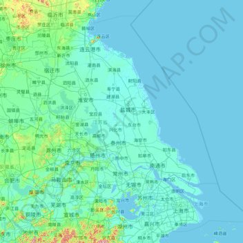
Naam: Topografische kaart Jiangsu, hoogte, reliëf.
Locatie: Jiangsu, China (30.76033 116.35520 35.16667 122.38666)
Gemiddelde hoogte: 24 m
Minimale hoogte: -3 m
Maximale hoogte: 1.144 m
Doe een donatie
Rust jezelf uit voor je volgende avontuur:
Als Amazon-partner verdient deze site een commissie op in aanmerking komende aankopen, zonder extra kosten voor jou.
Andere topografische kaarten
Klik op een kaart om zijn topografie, zijn hoogte en zijn reliëf te bekijken.
Shanghai
The golden age of Shanghai began with its elevation to municipality after it was separated from Jiangsu on 7 July 1927. This new Chinese municipality covered an area of 494.69 km2 (191.0 sq mi), including the modern-day districts of Baoshan, Yangpu, Zhabei, Nanshi, and Pudong, but excluded the foreign…
Gemiddelde hoogte: 5 m
Doe een donatie
Rust jezelf uit voor je volgende avontuur:
Als Amazon-partner verdient deze site een commissie op in aanmerking komende aankopen, zonder extra kosten voor jou.
Mount Makalu
China > Tibet > Tingri County
Makalu (Nepali: मकालु हिमाल, romanized: Makālu himāl; Chinese: 马卡鲁峰; pinyin: Mǎkǎlǔ Fēng) is the fifth-highest mountain on Earth, with a summit at an elevation of 8,485 metres (27,838 ft) AMSL. It is located in the Mahalangur Himalayas 19 km (12 mi) southeast of Mount Everest,…
Gemiddelde hoogte: 7.479 m
Turpan Depression
China > Xinjiang > Gaochang District
The Turpan Basin formed in a shear zone during the Late Permian due to motion between the East European and the Angaran craton. It was subsequently deformed by the collision of the Indian and Eurasian plates in the Cenozoic. In the latter deformation, a thrust fault belt running from east to west, the Flaming…
Gemiddelde hoogte: -152 m
Doe een donatie
Rust jezelf uit voor je volgende avontuur:
Als Amazon-partner verdient deze site een commissie op in aanmerking komende aankopen, zonder extra kosten voor jou.
Doe een donatie
Rust jezelf uit voor je volgende avontuur:
Als Amazon-partner verdient deze site een commissie op in aanmerking komende aankopen, zonder extra kosten voor jou.
Shanghai
The golden age of Shanghai began with its elevation to municipality after it was separated from Jiangsu on 7 July 1927. This new Chinese municipality covered an area of 494.69 km2 (191.0 sq mi), including the modern-day districts of Baoshan, Yangpu, Zhabei, Nanshi, and Pudong, but excluded the foreign…
Gemiddelde hoogte: 5 m
Golog Tibetan Autonomous Prefecture
China > Qinghai > Maqên County > Dawu
The lay of the land of the prefecture is largely determined by the Amne Machin mountain range (max elevation 6,282 m), which runs in the general northwest- to-southeast direction across the entire prefecture, and beyond. The existence of the ridge results in one of the great bends of the Yellow River, which…
Gemiddelde hoogte: 4.101 m
Doe een donatie
Rust jezelf uit voor je volgende avontuur:
Als Amazon-partner verdient deze site een commissie op in aanmerking komende aankopen, zonder extra kosten voor jou.
Doe een donatie
Rust jezelf uit voor je volgende avontuur:
Als Amazon-partner verdient deze site een commissie op in aanmerking komende aankopen, zonder extra kosten voor jou.
Doe een donatie
Rust jezelf uit voor je volgende avontuur:
Als Amazon-partner verdient deze site een commissie op in aanmerking komende aankopen, zonder extra kosten voor jou.
Golog Tibetan Autonomous Prefecture
China > Qinghai > Gadê County
The lay of the land of the prefecture is largely determined by the Amne Machin mountain range (max elevation 6,282 m), which runs in the general northwest- to-southeast direction across the entire prefecture, and beyond. The existence of the ridge results in one of the great bends of the Yellow River, which…
Gemiddelde hoogte: 4.340 m