
Doe een donatie
Rust jezelf uit voor je volgende avontuur:
Als Amazon-partner verdient deze site een commissie op in aanmerking komende aankopen, zonder extra kosten voor jou.
Topografische kaart Shanghai
Klik op de kaart om de hoogte weer te geven.
Doe een donatie
Rust jezelf uit voor je volgende avontuur:
Als Amazon-partner verdient deze site een commissie op in aanmerking komende aankopen, zonder extra kosten voor jou.
Shanghai
The golden age of Shanghai began with its elevation to municipality after it was separated from Jiangsu on 7 July 1927. This new Chinese municipality covered an area of 494.69 km2 (191.0 sq mi), including the modern-day districts of Baoshan, Yangpu, Zhabei, Nanshi, and Pudong, but excluded the foreign concessions territories. Headed by a Chinese mayor and municipal council, the new city government's first task—the Greater Shanghai Plan—was to create a new city center in Jiangwan town of Yangpu district, outside the boundaries of the foreign concessions. The plan included a public museum, library, sports stadium, and city hall, which were partially constructed before being interrupted by the Japanese invasion. In the 1920s, shidaiqu became a new form of entertainment and was popularised in Shanghai.
Doe een donatie
Rust jezelf uit voor je volgende avontuur:
Als Amazon-partner verdient deze site een commissie op in aanmerking komende aankopen, zonder extra kosten voor jou.
Over deze kaart
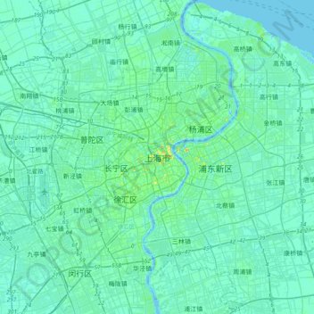
Naam: Topografische kaart Shanghai, hoogte, reliëf.
Locatie: Shanghai, Huangpu District, Shanghai, 200001, China (31.07234 121.30910 31.39234 121.62910)
Gemiddelde hoogte: 5 m
Minimale hoogte: -6 m
Maximale hoogte: 40 m
Doe een donatie
Rust jezelf uit voor je volgende avontuur:
Als Amazon-partner verdient deze site een commissie op in aanmerking komende aankopen, zonder extra kosten voor jou.