
Topografische kaart Kythira
Interactieve kaart
Klik op de kaart om de hoogte weer te geven.
Over deze kaart
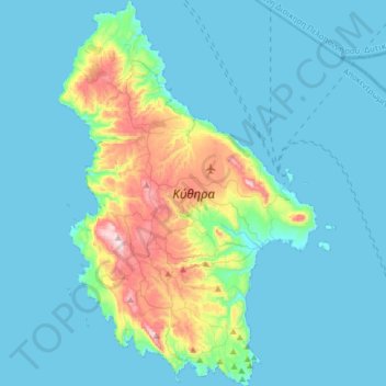
Naam: Topografische kaart Kythira, hoogte, reliëf.
Locatie: Kythira, Regional Unit of Islands, Attica, Greece (36.13024 22.89101 36.38578 23.10492)
Gemiddelde hoogte: 75 m
Minimale hoogte: 0 m
Maximale hoogte: 502 m
Andere topografische kaarten
Klik op een kaart om zijn topografie, zijn hoogte en zijn reliëf te bekijken.
Methana
Greece > Attica > Regional Unit of Islands > Municipal Unit of Methana
Methana, Municipal Unit of Methana, Municipality of Troizinia - Methana, Regional Unit of Islands, Attica, 180 30, Greece
Gemiddelde hoogte: 123 m
Lydia
Greece > Attica > Regional Unit of Islands
Lydia, Regional Unit of Islands, Attica, Greece
Gemiddelde hoogte: 4 m
Aegina
Greece > Attica > Regional Unit of Islands
Aegina, Municipality of Aegina, Regional Unit of Islands, Attica, 180 10, Greece
Gemiddelde hoogte: 27 m
Ampelakia Municipal Unit
Greece > Attica > Regional Unit of Islands
Ampelakia Municipal Unit, Municipality of Salamina, Regional Unit of Islands, Attica, 189 02, Greece
Gemiddelde hoogte: 55 m
Salamis
Greece > Attica > Regional Unit of Islands > Ampelakia Municipal Unit
Salamis, Ampelakia Municipal Unit, Municipality of Salamina, Regional Unit of Islands, Attica, Greece
Gemiddelde hoogte: 38 m
Poros
Greece > Attica > Regional Unit of Islands > Poros
Poros, Municipality of Poros, Regional Unit of Islands, Attica, 180 20, Greece
Gemiddelde hoogte: 31 m
Spetses
Greece > Attica > Regional Unit of Islands > Spetses
Spetses, Municipality of Spetses, Regional Unit of Islands, Attica, 180 50, Greece
Gemiddelde hoogte: 33 m
Aegina
Greece > Attica > Regional Unit of Islands > Kontos
Aegina, Kontos, Municipality of Aegina, Regional Unit of Islands, Attica, 180 10, Greece
Gemiddelde hoogte: 60 m
Perani
Greece > Attica > Regional Unit of Islands > Salamina Municipal Unit
Perani, Salamina Municipal Unit, Municipality of Salamina, Regional Unit of Islands, Attica, 189 03, Greece
Gemiddelde hoogte: 67 m
Hydra
Greece > Attica > Regional Unit of Islands > Vlychos
Hydra, Vlychos, Municipality of Hydra, Regional Unit of Islands, Attica, 180 40, Greece
Gemiddelde hoogte: 26 m