
Topografische kaart Methana
Interactieve kaart
Klik op de kaart om de hoogte weer te geven.
Over deze kaart
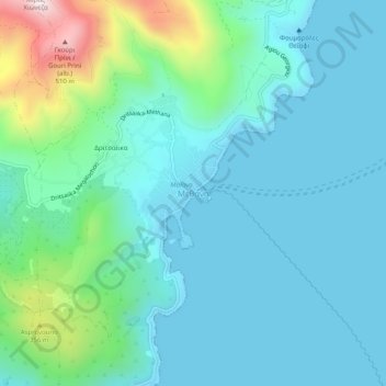
Naam: Topografische kaart Methana, hoogte, reliëf.
Gemiddelde hoogte: 123 m
Minimale hoogte: -2 m
Maximale hoogte: 667 m
Since 1991, the peninsula has been investigated by the team of ETH Zürich geologically and cartographically. From this, a topographical map of the entire peninsula at a scale of 1:25,000 was made. An interactive 3D map was created and is on the World Wide Web. Also a rich photographic archive with about 10.000 color slides has been produced (see links below).