
Topografische kaart Samothraki
Interactieve kaart
Klik op de kaart om de hoogte weer te geven.
Samothraki
Samothraki has a hot-summer Mediterranean climate. Winters are cool and rainy with occasional heavy snowstorms, especially at higher elevations.
Over deze kaart
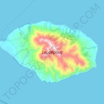
Naam: Topografische kaart Samothraki, hoogte, reliëf.
Gemiddelde hoogte: 170 m
Minimale hoogte: 0 m
Maximale hoogte: 1.598 m
Andere topografische kaarten
Klik op een kaart om zijn topografie, zijn hoogte en zijn reliëf te bekijken.
Paliouri
Greece > Macedonia and Thrace > Evros Regional Unit > Metaxades Municipal Unit
Gemiddelde hoogte: 132 m
Mani
Greece > Macedonia and Thrace > Evros Regional Unit > Didymoteicho Municipal Unit
Mani (Greek: Μάνη) is a village and a community in the municipality of Didymoteicho in the Evros regional unit, Greece. It is situated near the left bank of the river Erythropotamos, 2 km west of Karoti, 4 km northeast of Kyani and 10 km northwest of Didymoteicho town centre. In 2021 its population was 364…
Gemiddelde hoogte: 53 m