
Topografische kaart Avas
Interactieve kaart
Klik op de kaart om de hoogte weer te geven.
Over deze kaart
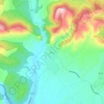
Naam: Topografische kaart Avas, hoogte, reliëf.
Gemiddelde hoogte: 163 m
Minimale hoogte: 51 m
Maximale hoogte: 396 m
Andere topografische kaarten
Klik op een kaart om zijn topografie, zijn hoogte en zijn reliëf te bekijken.
Samothraki
Greece > Macedonia and Thrace > Evros Regional Unit
Samothraki, Evros Regional Unit, Eastern Macedonia and Thrace, Macedonia and Thrace, 680 02, Greece
Gemiddelde hoogte: 170 m
Kyprinos
Greece > Macedonia and Thrace > Evros Regional Unit > Kyprinos
Kyprinos, Δήμος Ορεστιάδας, Evros Regional Unit, Eastern Macedonia and Thrace, Macedonia and Thrace, 68006, Greece
Gemiddelde hoogte: 68 m
Orestiada
Greece > Macedonia and Thrace > Evros Regional Unit > Orestiada
Orestiada, Δήμος Ορεστιάδας, Evros Regional Unit, Eastern Macedonia and Thrace, Macedonia and Thrace, 68200, Greece
Gemiddelde hoogte: 41 m
Alexandroupoli
Greece > Macedonia and Thrace > Evros Regional Unit
Alexandroupoli, Municipality of Alexandroupoli, Evros Regional Unit, Eastern Macedonia and Thrace, Macedonia and Thrace, 681 00, Greece
Gemiddelde hoogte: 95 m
Νέα Χηλή
Greece > Macedonia and Thrace > Evros Regional Unit
Νέα Χηλή, Municipality of Alexandroupoli, Evros Regional Unit, Eastern Macedonia and Thrace, Macedonia and Thrace, 681 00, Greece
Gemiddelde hoogte: 27 m