
Topografische kaart Ada County
Interactieve kaart
Klik op de kaart om de hoogte weer te geven.
Over deze kaart
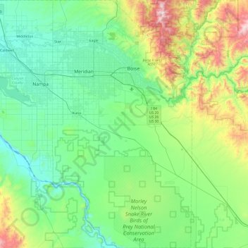
Naam: Topografische kaart Ada County, hoogte, reliëf.
Locatie: Ada County, Idaho, United States of America (43.11329 -116.51413 43.80865 -115.97385)
Gemiddelde hoogte: 1.004 m
Minimale hoogte: 680 m
Maximale hoogte: 2.279 m
Andere topografische kaarten
Klik op een kaart om zijn topografie, zijn hoogte en zijn reliëf te bekijken.
Boise
United States of America > Idaho > Boise
Boise, Ada County, Idaho, 83702, United States of America
Gemiddelde hoogte: 1.040 m
Shoshone County
United States of America > Idaho
Shoshone County, Idaho, United States of America
Gemiddelde hoogte: 1.204 m
Lake Pend Oreille
United States of America > Idaho > Cedar Creek
Lake Pend Oreille, National Forest Development Road 278, Cedar Creek, Bonner County, Idaho, 83803, United States of America
Gemiddelde hoogte: 941 m
Lemhi County
United States of America > Idaho
Lemhi County, Idaho, United States of America
Gemiddelde hoogte: 2.146 m