
Topografische kaart Boise
Interactieve kaart
Klik op de kaart om de hoogte weer te geven.
Over deze kaart
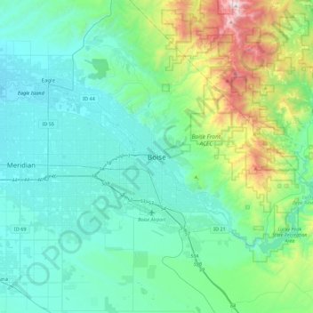
Naam: Topografische kaart Boise, hoogte, reliëf.
Locatie: Boise, Ada County, Idaho, 83702, United States of America (43.45662 -116.36089 43.77662 -116.04089)
Gemiddelde hoogte: 1.040 m
Minimale hoogte: 762 m
Maximale hoogte: 2.303 m
Boise (/ˈbɔɪsi/ (listen)) is the capital and most populous city of the U.S. state of Idaho, and is the county seat of Ada County. Located on the Boise River in southwestern Idaho, it is 41 miles (66 km) east of the Oregon border, and 110 miles (177 km) north of the Nevada border. The downtown area's elevation is 2,704 feet (824 m) above sea level. Its estimated population in 2018 was 228,790.