
Topografische kaart Lägh dal Lunghin
Interactieve kaart
Klik op de kaart om de hoogte weer te geven.
Lägh dal Lunghin
Lägh dal Lunghin (German: Lunghinsee) is a lake at an elevation of 2484 m, below the peak of Piz Lunghin, in the Graubünden, Switzerland. It is considered the source of the Inn River.
Over deze kaart
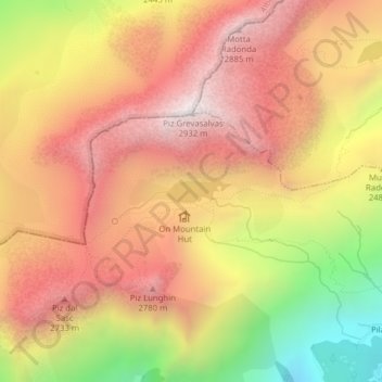
Naam: Topografische kaart Lägh dal Lunghin, hoogte, reliëf.
Locatie: Lägh dal Lunghin, Bregaglia, Maloja, Grisons, Switzerland (46.41656 9.67187 46.41814 9.67833)
Gemiddelde hoogte: 2.456 m
Minimale hoogte: 1.771 m
Maximale hoogte: 2.915 m
Andere topografische kaarten
Klik op een kaart om zijn topografie, zijn hoogte en zijn reliëf te bekijken.
Sankt Moritz
Switzerland > Grisons > Maloja
St. Moritz (/ˌsæn məˈrɪts/ SAN mə-RITS, US also /ˌseɪnt -/ SAYNT -, UK also /sənt ˈmɒrɪts/ sənt MORR-its; German, in full: Sankt Moritz [zaŋkt moˈrɪts, ˈmoːrɪts] locally [saŋkt]; Romansh: San Murezzan [sam muˈʁetsən] ; Italian: San Maurizio; French: Saint-Moritz) is a high Alpine…
Gemiddelde hoogte: 2.173 m
Pontresina
Switzerland > Grisons > Maloja
Before 2017, the municipality was located in the Oberengadin sub-district of the Maloja district, after 2017 it was part of the Maloja Region. It sits in Val Bernina, which is the highest altitude valley that branches off the Upper Engadin Valley. The municipality includes the highest mountain of the canton,…
Gemiddelde hoogte: 2.580 m
Albulapass
Switzerland > Grisons > Maloja > La Punt Chamues-ch
The Albula Pass is an important axis from central Graubünden to Engadin. It is traversed by a paved road from Thusis to La Punt, via Bergün. It is also traversed by the Albula Railway, although at a lower elevation through the Albula Tunnel (1,820 m), from Thusis to Bever, also via Bergün.
Gemiddelde hoogte: 2.560 m
Sankt Moritz
Switzerland > Grisons > Maloja
St. Moritz (also German: Sankt Moritz, Romansh: San Murezzan (help·info), Italian: San Maurizio, French: Saint-Moritz) is a high Alpine resort town in the Engadine in Switzerland, at an elevation of about 1,800 metres (5,910 ft) above sea level. It is Upper Engadine's major town and a municipality in the…
Gemiddelde hoogte: 2.173 m
Casaccia
Switzerland > Grisons > Maloja
Casaccia is a village located in the Val Bregaglia, in the Swiss canton of Graubünden. It lies at an altitude of 1,458 metres above sea level, at the southern foot of Piz Lunghin. The village belongs to the municipality of Bregaglia.
Gemiddelde hoogte: 1.929 m