
Topografische kaart Charlevoix
Klik op de kaart om de hoogte weer te geven.
Over deze kaart
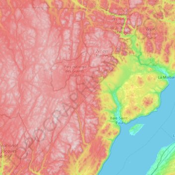
Naam: Topografische kaart Charlevoix, hoogte, reliëf.
Locatie: Charlevoix, Capitale-Nationale, Quebec, Canada (47.20685 -71.41161 47.99999 -70.13173)
Gemiddelde hoogte: 593 m
Minimale hoogte: 0 m
Maximale hoogte: 1.158 m
Andere topografische kaarten
Klik op een kaart om zijn topografie, zijn hoogte en zijn reliëf te bekijken.
Mount Royal
Canada > Quebec > Urban agglomeration of Montreal > Montreal
The hill is part of the Monteregian Hills situated between the Laurentians and the Appalachian Mountains. It gave its Latin name, Mons Regius, to the Monteregian chain. The hill consists of three peaks: Colline de la Croix (or Mont Royal proper) at 233 m (764 ft), Colline d'Outremont (or Mount Murray, in the…
Gemiddelde hoogte: 111 m
Saint-Pierre de Wakefield
Canada > Quebec > Les Collines-de-l'Outaouais > Val-des-Monts
Gemiddelde hoogte: 224 m
Quebec
Canada > Quebec > Urban agglomeration of Québec
Quebec City was built on the north bank of the Saint Lawrence River, where it narrows and meets the mouth of the Saint-Charles River. Old Quebec is located on top and at the foot of Cap-Diamant, which is on the eastern edge of a plateau called the promontory of Quebec (Quebec hill). Because of this topographic…
Gemiddelde hoogte: 100 m
Gault Nature Reserve
Canada > Quebec > La Vallée-du-Richelieu > Mont-Saint-Hilaire
Gemiddelde hoogte: 189 m
Parc Léon-Provancher
Canada > Quebec > Urban agglomeration of Montreal > Montreal
Gemiddelde hoogte: 53 m
Saint Helen's Island
Canada > Quebec > Urban agglomeration of Montreal > Montreal
Gemiddelde hoogte: 15 m
Lac Marier
Canada > Quebec > Les Pays-d'en-Haut > Sainte-Marguerite-du-Lac-Masson
Gemiddelde hoogte: 377 m
Lac de l'Équerre
Canada > Quebec > Urban agglomeration of La Tuque > La Tuque
Gemiddelde hoogte: 309 m
Richmond Gulf
Canada > Quebec > Kativik > Baie-d'Hudson
The topography of Lake Tasuijaq is the consequence of two geological faults running parallel to the coast. The resulting dislocation has given rise to the cliffs that dominate the western shore of the lake.
Gemiddelde hoogte: 0 m
Lac Saint-Thomas
Canada > Quebec > La Jacques-Cartier > Stoneham-et-Tewkesbury
Gemiddelde hoogte: 505 m
Chisasibi (partie Inuit)
Canada > Quebec > Jamésie > Chisasibi (Land) > Chisasibi
Gemiddelde hoogte: 11 m
Saint-Marc-du-Lac-Long
Canada > Quebec > Témiscouata > Saint-Marc-du-Lac-Long
Gemiddelde hoogte: 258 m
Saint-Louis-de-Masham
Canada > Quebec > Les Collines-de-l'Outaouais > La Pêche
Gemiddelde hoogte: 186 m
Scouts Canada - Lake Lovering Scouts Reserve
Canada > Quebec > Memphrémagog > Magog
Gemiddelde hoogte: 260 m