
Topografische kaart Pamlico County
Interactieve kaart
Klik op de kaart om de hoogte weer te geven.
Over deze kaart
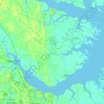
Naam: Topografische kaart Pamlico County, hoogte, reliëf.
Locatie: Pamlico County, North Carolina, United States of America (34.95043 -76.98757 35.36186 -76.30414)
Gemiddelde hoogte: 5 m
Minimale hoogte: -10 m
Maximale hoogte: 41 m
The county was formed in 1872 from parts of Beaufort and Craven counties. It was named for Pamlico Sound, which adjoins it. Vernacular usage in the area, especially in Craven County, refers to Pamlico County as being "down in the county." Prior to 1872, it was a part of Craven County and has a very low elevation. Most of the county, according to FRIS, North Carolina Flood Risk Information System, is subject to flooding in storm surges. After it was separated from Craven, the old nickname survives. Pamlico County remains rural in character and flavor, although the last decade has brought a good deal of residential development, largely the result of northern retirees and investors attracted to the many miles of waterfront property.
Andere topografische kaarten
Klik op een kaart om zijn topografie, zijn hoogte en zijn reliëf te bekijken.
Avon
United States of America > North Carolina > Avon
Avon, Dare County, North Carolina, 27915, United States of America
Gemiddelde hoogte: 0 m
Buncombe County
United States of America > North Carolina
Buncombe County, North Carolina, United States of America
Gemiddelde hoogte: 839 m
Rockingham County
United States of America > North Carolina
Rockingham County, North Carolina, United States of America
Gemiddelde hoogte: 222 m
Lincoln County
United States of America > North Carolina
Lincoln County, North Carolina, United States of America
Gemiddelde hoogte: 266 m
Jones County
United States of America > North Carolina
Jones County, North Carolina, United States of America
Gemiddelde hoogte: 13 m
Graham County
United States of America > North Carolina
Graham County, North Carolina, United States of America
Gemiddelde hoogte: 850 m