
Topografische kaart Lincoln County
Interactieve kaart
Klik op de kaart om de hoogte weer te geven.
Over deze kaart
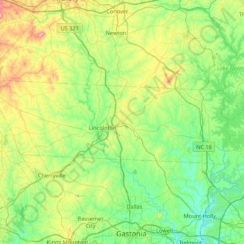
Naam: Topografische kaart Lincoln County, hoogte, reliëf.
Locatie: Lincoln County, North Carolina, United States of America (35.40007 -81.53775 35.57016 -80.94046)
Gemiddelde hoogte: 266 m
Minimale hoogte: 173 m
Maximale hoogte: 544 m
Andere topografische kaarten
Klik op een kaart om zijn topografie, zijn hoogte en zijn reliëf te bekijken.
Avon
United States of America > North Carolina > Avon
Avon, Dare County, North Carolina, 27915, United States of America
Gemiddelde hoogte: 0 m
Buncombe County
United States of America > North Carolina
Buncombe County, North Carolina, United States of America
Gemiddelde hoogte: 839 m
Rockingham County
United States of America > North Carolina
Rockingham County, North Carolina, United States of America
Gemiddelde hoogte: 222 m
Jones County
United States of America > North Carolina
Jones County, North Carolina, United States of America
Gemiddelde hoogte: 13 m
Pamlico County
United States of America > North Carolina
Pamlico County, North Carolina, United States of America
Gemiddelde hoogte: 5 m
Graham County
United States of America > North Carolina
Graham County, North Carolina, United States of America
Gemiddelde hoogte: 850 m