
Topografische kaart Harlan
Interactieve kaart
Klik op de kaart om de hoogte weer te geven.
Over deze kaart
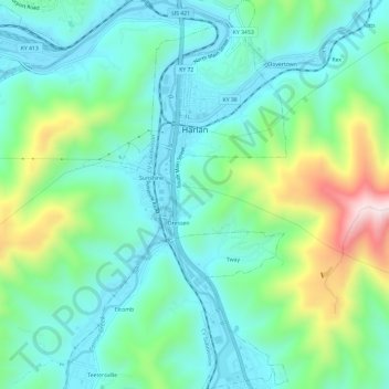
Naam: Topografische kaart Harlan, hoogte, reliëf.
Locatie: Harlan, Harlan County, Kentucky, 40831, United States (36.81142 -83.33322 36.85899 -83.30762)
Gemiddelde hoogte: 493 m
Minimale hoogte: 350 m
Maximale hoogte: 910 m
Harlan is located in west-central Harlan County at 36°50′29″N 83°19′12″W / 36.84139°N 83.32000°W / 36.84139; -83.32000 (36.841487, -83.320066), at the junction of the Clover Fork and Martin's Fork rivers. The Clover Fork continues north 1.5 miles (2.4 km) to join the Poor Fork, forming the Cumberland River, a major tributary of the Ohio River. Harlan is in a narrow mountain valley, constrained to the north by the western end of Black Mountain, to the south by Little Black Mountain, and to the west by Ewing Spur. The elevation at the Harlan Courthouse is 1,197 feet (365 m) above sea level, while the surrounding ridges rise outside the city limits to 2,100 feet (640 m) (Black Mountain), 3,000 feet (910 m) (Little Black Mountain), and 2,300 feet (700 m) (Ewing Spur).
Andere topografische kaarten
Klik op een kaart om zijn topografie, zijn hoogte en zijn reliëf te bekijken.
Pathfork
United States > Kentucky > Harlan County
Pathfork, Harlan County, Kentucky, 40863, United States
Gemiddelde hoogte: 534 m
Lenarue
United States > Kentucky > Harlan County
Lenarue, Harlan County, Kentucky, 40818, United States
Gemiddelde hoogte: 519 m
Bardo
United States > Kentucky > Harlan County
Bardo, Harlan County, Kentucky, 40830, United States
Gemiddelde hoogte: 634 m
Holmes Mill
United States > Kentucky > Harlan County
Holmes Mill, Harlan County, Kentucky, 40843, United States
Gemiddelde hoogte: 758 m
Pansy
United States > Kentucky > Harlan County
Pansy, Harlan County, Kentucky, 40830, United States
Gemiddelde hoogte: 602 m
Putney
United States > Kentucky > Harlan County
Putney, Harlan County, Kentucky, 40865, United States
Gemiddelde hoogte: 601 m
Alva
United States > Kentucky > Harlan County
Alva, Harlan County, Kentucky, 40863, United States
Gemiddelde hoogte: 652 m
Yancey
United States > Kentucky > Harlan County
Yancey, Harlan County, Kentucky, 40830, United States
Gemiddelde hoogte: 651 m
Fresh Meadows
United States > Kentucky > Harlan County
Fresh Meadows, Harlan County, Kentucky, 40824, United States
Gemiddelde hoogte: 462 m
Pine Mountain
United States > Kentucky > Harlan County
Pine Mountain, Harlan County, Kentucky, United States
Gemiddelde hoogte: 536 m
Kenvir
United States > Kentucky > Harlan County
Kenvir, Harlan County, Kentucky, 40847, United States
Gemiddelde hoogte: 642 m
Ages
United States > Kentucky > Harlan County
Ages, Harlan County, Kentucky, 40801, United States
Gemiddelde hoogte: 587 m
Wallins Creek
United States > Kentucky > Harlan County
Wallins Creek, Harlan County, Kentucky, United States
Gemiddelde hoogte: 416 m
Lejunior
United States > Kentucky > Harlan County
Lejunior, Harlan County, Kentucky, 40865, United States
Gemiddelde hoogte: 585 m
Three Point
United States > Kentucky > Harlan County
Three Point, Harlan County, Kentucky, 40815, United States
Gemiddelde hoogte: 475 m
Louellen
United States > Kentucky > Harlan County
Louellen, Harlan County, Kentucky, 40849, United States
Gemiddelde hoogte: 698 m
Big Laurel
United States > Kentucky > Harlan County
Big Laurel, Harlan County, Kentucky, 40808, United States
Gemiddelde hoogte: 574 m
Cawood
United States > Kentucky > Harlan County
Cawood, Harlan County, Kentucky, 40818, United States
Gemiddelde hoogte: 498 m
South Wallins
United States > Kentucky > Harlan County > South Wallins
South Wallins, Harlan County, Kentucky, 40873, United States
Gemiddelde hoogte: 528 m
Dayhoit
United States > Kentucky > Harlan County
Dayhoit, Harlan County, Kentucky, 40824, United States
Gemiddelde hoogte: 462 m
Loyall
United States > Kentucky > Harlan County
Loyall, Harlan County, Kentucky, 40854, United States
Gemiddelde hoogte: 434 m
Molus
United States > Kentucky > Harlan County
Molus, Harlan County, Kentucky, 40819, United States
Gemiddelde hoogte: 467 m
Closplint
United States > Kentucky > Harlan County
Closplint, Harlan County, Kentucky, 40927, United States
Gemiddelde hoogte: 716 m
Benham
United States > Kentucky > Harlan County
Benham, Harlan County, Kentucky, 40807, United States
Gemiddelde hoogte: 667 m
Totz
United States > Kentucky > Harlan County
Totz, Harlan County, Kentucky, 40870, United States
Gemiddelde hoogte: 638 m
Bledsoe
United States > Kentucky > Harlan County
Bledsoe, Harlan County, Kentucky, 40810, United States
Gemiddelde hoogte: 604 m
Creech
United States > Kentucky > Harlan County
Creech, Harlan County, Kentucky, United States
Gemiddelde hoogte: 661 m
River Ridge
United States > Kentucky > Harlan County
River Ridge, Harlan County, Kentucky, 40828, United States
Gemiddelde hoogte: 584 m
Evarts
United States > Kentucky > Harlan County
Evarts, Harlan County, Kentucky, United States
Gemiddelde hoogte: 533 m
Baxter
United States > Kentucky > Harlan County
Baxter, Harlan County, Kentucky, 40806, United States
Gemiddelde hoogte: 468 m
Coldiron
United States > Kentucky > Harlan County
Coldiron, Harlan County, Kentucky, 40819, United States
Gemiddelde hoogte: 472 m
Lynch
United States > Kentucky > Harlan County
Lynch, Harlan County, Kentucky, United States
Gemiddelde hoogte: 770 m
Divide
United States > Kentucky > Harlan County
Divide, Harlan County, Kentucky, 40865, United States
Gemiddelde hoogte: 657 m
Cranks
United States > Kentucky > Harlan County
Cranks, Harlan County, Kentucky, 40820, United States
Gemiddelde hoogte: 594 m
Harlan
United States > Kentucky > Harlan County > Harlan > Harlan
Harlan, Harlan County, Kentucky, 40831, United States
Gemiddelde hoogte: 512 m
Cumberland
United States > Kentucky > Harlan County
Cumberland, Harlan County, Kentucky, 40823, United States
Gemiddelde hoogte: 591 m