
Topografische kaart Harlan
Interactieve kaart
Klik op de kaart om de hoogte weer te geven.
Harlan
Harlan is located in west-central Harlan County at 36°50′29″N 83°19′12″W / 36.84139°N 83.32000°W / 36.84139; -83.32000 (36.841487, -83.320066), at the junction of the Clover Fork and Martin's Fork rivers. The Clover Fork continues north 1.5 miles (2.4 km) to join the Poor Fork, forming the Cumberland River, a major tributary of the Ohio River. Harlan is in a narrow mountain valley, constrained to the north by the western end of Black Mountain, to the south by Little Black Mountain, and to the west by Ewing Spur. The elevation at the Harlan Courthouse is 1,197 feet (365 m) above sea level, while the surrounding ridges rise outside the city limits to 2,100 feet (640 m) (Black Mountain), 3,000 feet (910 m) (Little Black Mountain), and 2,300 feet (700 m) (Ewing Spur).
Over deze kaart
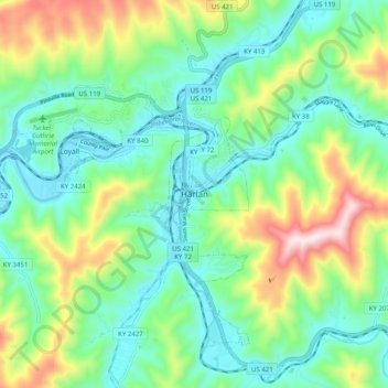
Naam: Topografische kaart Harlan, hoogte, reliëf.
Locatie: Harlan, Harlan County, Kentucky, 40831, United States (36.80314 -83.36185 36.88314 -83.28185)
Gemiddelde hoogte: 512 m
Minimale hoogte: 347 m
Maximale hoogte: 910 m