
Topografische kaart Melrose
Interactieve kaart
Klik op de kaart om de hoogte weer te geven.
Over deze kaart
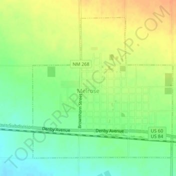
Naam: Topografische kaart Melrose, hoogte, reliëf.
Locatie: Melrose, Curry County, New Mexico, United States (34.42028 -103.64264 34.44188 -103.61652)
Gemiddelde hoogte: 1.345 m
Minimale hoogte: 1.326 m
Maximale hoogte: 1.365 m
Andere topografische kaarten
Klik op een kaart om zijn topografie, zijn hoogte en zijn reliëf te bekijken.
Cannon AFB
United States > New Mexico > Curry County
Cannon AFB, Curry County, New Mexico, 88103, United States
Gemiddelde hoogte: 1.308 m
Grady
United States > New Mexico > Curry County
Grady, Curry County, New Mexico, 88120, United States
Gemiddelde hoogte: 1.404 m
Broadview
United States > New Mexico > Curry County
Broadview, Curry County, New Mexico, United States
Gemiddelde hoogte: 1.376 m
Ranchvale
United States > New Mexico > Curry County
Ranchvale, Curry County, New Mexico, United States
Gemiddelde hoogte: 1.361 m
Saint Vrain
United States > New Mexico > Curry County
Saint Vrain, Curry County, New Mexico, United States
Gemiddelde hoogte: 1.341 m
Texico
United States > New Mexico > Curry County
Texico, Curry County, New Mexico, 88135, United States
Gemiddelde hoogte: 1.264 m
Clovis
United States > New Mexico > Curry County
Clovis, Curry County, New Mexico, 88101, United States
Gemiddelde hoogte: 1.317 m
Clovis
United States > New Mexico > Curry County > Clovis
Clovis, Curry County, New Mexico, 88101, United States
Gemiddelde hoogte: 1.295 m