
Topografische kaart Clovis
Interactieve kaart
Klik op de kaart om de hoogte weer te geven.
Over deze kaart
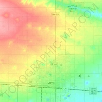
Naam: Topografische kaart Clovis, hoogte, reliëf.
Locatie: Clovis, Curry County, New Mexico, 88101, United States (34.37570 -103.26236 34.53217 -103.13462)
Gemiddelde hoogte: 1.317 m
Minimale hoogte: 1.275 m
Maximale hoogte: 1.363 m
Clovis is located in southeastern Curry County at 34°24′45″N 103°12′17″W / 34.41250°N 103.20472°W / 34.41250; -103.20472 (34.412509, −103.204611), 9 miles (14 km) west of the Texas border. The city's geographic center is at an elevation of 4,281 feet (1,305 m) above sea level.
Andere topografische kaarten
Klik op een kaart om zijn topografie, zijn hoogte en zijn reliëf te bekijken.
Cannon AFB
United States > New Mexico > Curry County
Cannon AFB, Curry County, New Mexico, 88103, United States
Gemiddelde hoogte: 1.308 m
Grady
United States > New Mexico > Curry County
Grady, Curry County, New Mexico, 88120, United States
Gemiddelde hoogte: 1.404 m
Broadview
United States > New Mexico > Curry County
Broadview, Curry County, New Mexico, United States
Gemiddelde hoogte: 1.376 m
Melrose
United States > New Mexico > Curry County
Melrose, Curry County, New Mexico, United States
Gemiddelde hoogte: 1.345 m
Ranchvale
United States > New Mexico > Curry County
Ranchvale, Curry County, New Mexico, United States
Gemiddelde hoogte: 1.361 m
Saint Vrain
United States > New Mexico > Curry County
Saint Vrain, Curry County, New Mexico, United States
Gemiddelde hoogte: 1.341 m
Texico
United States > New Mexico > Curry County
Texico, Curry County, New Mexico, 88135, United States
Gemiddelde hoogte: 1.264 m
Clovis
United States > New Mexico > Curry County > Clovis
Clovis, Curry County, New Mexico, 88101, United States
Gemiddelde hoogte: 1.295 m