
Topografische kaart Fraser
Klik op de kaart om de hoogte weer te geven.
Fraser
Fraser is located in southeastern Grand County at 39°56′39″N 105°48′48″W / 39.94417°N 105.81333°W / 39.94417; -105.81333 (39.944158, -105.813355), at an elevation of 8,574 feet (2,613 m) above sea level. It is bordered to the south by the town of Winter Park and to the north by unincorporated Tabernash. U.S. Route 40 leads south and east across Berthoud Pass 71 miles (114 km) to Denver, and northwest 15 miles (24 km) to Granby, the largest town in Grand County.
Over deze kaart
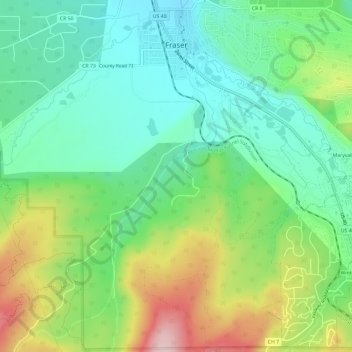
Naam: Topografische kaart Fraser, hoogte, reliëf.
Locatie: Fraser, Grand County, Colorado, 80442, United States (39.90779 -105.82230 39.95298 -105.77621)
Gemiddelde hoogte: 2.696 m
Minimale hoogte: 2.599 m
Maximale hoogte: 2.888 m
Andere topografische kaarten
Klik op een kaart om zijn topografie, zijn hoogte en zijn reliëf te bekijken.
Winter Park
United States > Colorado > Grand County
Its elevation ranges from approximately 8,700 to 12,060 feet (2,650 to 3,680 m) above sea level, and is considered sub-alpine country. It is snow-covered for about six months a year. Although the town center is at about 9,000 feet (2,700 m) above sea level, Winter Park, using administrative boundaries as a…
Gemiddelde hoogte: 3.061 m