
Topografische kaart Gaskil
Klik op de kaart om de hoogte weer te geven.
Over deze kaart
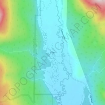
Naam: Topografische kaart Gaskil, hoogte, reliëf.
Locatie: Gaskil, Grand County, Colorado, United States (40.31054 -105.88223 40.35054 -105.84223)
Gemiddelde hoogte: 2.790 m
Minimale hoogte: 2.662 m
Maximale hoogte: 3.196 m
Andere topografische kaarten
Klik op een kaart om zijn topografie, zijn hoogte en zijn reliëf te bekijken.
Grand Lake
United States > Colorado > Grand County
Established in 1881, Grand Lake sits at an elevation of 8,369 feet (2,551 m) and derives its name from the lake on whose shores it is situated: Grand Lake, the largest natural body of water in Colorado. The town of Grand Lake was originally an outfitting and supply point for the mining settlements of Lulu…
Gemiddelde hoogte: 2.630 m
Winter Park
United States > Colorado > Grand County
Its elevation ranges from approximately 8,700 to 12,060 feet (2,650 to 3,680 m) above sea level, and is considered sub-alpine country. It is snow-covered for about six months a year. Although the town center is at about 9,000 feet (2,700 m) above sea level, Winter Park, using administrative boundaries as a…
Gemiddelde hoogte: 3.061 m
Tabernash
United States > Colorado > Grand County > Tabernash
On August 10, 1984, a Cessna L-19 Bird Dog (registration N4584A), piloted by James Jeb Caddell, 36, crashed in a forest near Tabernash. The aircraft was en route from Granby to Jeffco Airport, Colorado. Despite the efforts of a search party, the two men could not be located, as the plane had flipped over and…
Gemiddelde hoogte: 2.593 m
Winter Park
United States > Colorado > Grand County
Its elevation ranges from approximately 8,700 to 12,060 feet (2,650 to 3,680 m) above sea level, and is considered sub-alpine country. It is snow-covered for about six months a year. Although the town center is at about 9,000 feet (2,700 m) above sea level, Winter Park, using administrative boundaries as a…
Gemiddelde hoogte: 3.061 m
Fraser
United States > Colorado > Grand County
Fraser is located in southeastern Grand County at 39°56′39″N 105°48′48″W / 39.94417°N 105.81333°W / 39.94417; -105.81333 (39.944158, -105.813355), at an elevation of 8,574 feet (2,613 m) above sea level. It is bordered to the south by the town of Winter Park and to the north by…
Gemiddelde hoogte: 2.696 m
Grand Lake
United States > Colorado > Grand County
Established in 1881, Grand Lake sits at an elevation of 8,369 feet (2,551 m) and derives its name from the lake on whose shores it is situated: Grand Lake, the largest natural body of water in Colorado. The town of Grand Lake was originally an outfitting and supply point for the mining settlements of Lulu…
Gemiddelde hoogte: 2.630 m
Tabernash
United States > Colorado > Grand County
On August 10, 1984, a Cessna L-19 Bird Dog (registration N4584A), piloted by James Jeb Caddell, 36, crashed in a forest near Tabernash. The aircraft was en route from Granby to Jeffco Airport, Colorado. The wreckage was found by backpackers three years later on August 23, 1987. A 6½ minute video shot from a…
Gemiddelde hoogte: 2.593 m