
Topografische kaart West Clare Municipal District
Interactieve kaart
Klik op de kaart om de hoogte weer te geven.
Over deze kaart
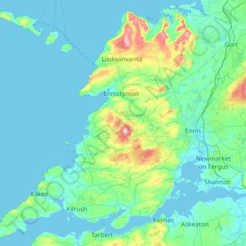
Naam: Topografische kaart West Clare Municipal District, hoogte, reliëf.
Locatie: West Clare Municipal District, County Clare, Munster, Irland (52.55447 -9.93876 53.16891 -8.88244)
Gemiddelde hoogte: 37 m
Minimale hoogte: -2 m
Maximale hoogte: 386 m
Andere topografische kaarten
Klik op een kaart om zijn topografie, zijn hoogte en zijn reliëf te bekijken.
Cliffs of Moher
Cliffs of Moher, Ballysteen ED, West Clare Municipal District, County Clare, Munster, Irland
Gemiddelde hoogte: 55 m
Killaloe Municipal District
Killaloe Municipal District, County Clare, Munster, Irland
Gemiddelde hoogte: 85 m
Ennis Municipal District
Ennis Municipal District, County Clare, Munster, Irland
Gemiddelde hoogte: 39 m
Balliny South
Balliny South, Derreen ED, West Clare Municipal District, County Clare, Munster, Irland
Gemiddelde hoogte: 253 m
Scarriff
Irland > County Clare > Scarriff
Scarriff, Killaloe Municipal District, County Clare, Munster, Irland
Gemiddelde hoogte: 52 m
Mountshannon
Irland > County Clare > Mountshannon
Mountshannon, Killaloe Municipal District, County Clare, Munster, Irland
Gemiddelde hoogte: 52 m
Shannon
Irland > County Clare > Shannon
Shannon, Shannon Municipal District, County Clare, Munster, V14 AK19, Irland
Gemiddelde hoogte: 10 m
Loop Head
Loop Head, Kilbaha South, Kilballyowen ED, West Clare Municipal District, County Clare, Munster, Irland
Gemiddelde hoogte: 5 m
Liscannor
Irland > County Clare > Liscannor
Liscannor, Liscannor ED, West Clare Municipal District, County Clare, Munster, Irland
Gemiddelde hoogte: 12 m
Doolin
Irland > County Clare > Doolin
Doolin, Killilagh ED, West Clare Municipal District, County Clare, Munster, V95-V9P1, Irland
Gemiddelde hoogte: 38 m