
Topografische kaart Balliny South
Interactieve kaart
Klik op de kaart om de hoogte weer te geven.
Over deze kaart
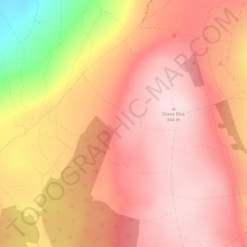
Naam: Topografische kaart Balliny South, hoogte, reliëf.
Gemiddelde hoogte: 253 m
Minimale hoogte: 40 m
Maximale hoogte: 341 m
Andere topografische kaarten
Klik op een kaart om zijn topografie, zijn hoogte en zijn reliëf te bekijken.
Killaloe Municipal District
Killaloe Municipal District, County Clare, Munster, Irland
Gemiddelde hoogte: 85 m
Ennis Municipal District
Ennis Municipal District, County Clare, Munster, Irland
Gemiddelde hoogte: 39 m
Scarriff
Irland > County Clare > Scarriff
Scarriff, Killaloe Municipal District, County Clare, Munster, Irland
Gemiddelde hoogte: 52 m
Mountshannon
Irland > County Clare > Mountshannon
Mountshannon, Killaloe Municipal District, County Clare, Munster, Irland
Gemiddelde hoogte: 52 m
Shannon
Irland > County Clare > Shannon
Shannon, Shannon Municipal District, County Clare, Munster, V14 AK19, Irland
Gemiddelde hoogte: 10 m
Loop Head
Loop Head, Kilbaha South, Kilballyowen ED, West Clare Municipal District, County Clare, Munster, Irland
Gemiddelde hoogte: 5 m
Liscannor
Irland > County Clare > Liscannor
Liscannor, Liscannor ED, West Clare Municipal District, County Clare, Munster, Irland
Gemiddelde hoogte: 12 m
Doolin
Irland > County Clare > Doolin
Doolin, Killilagh ED, West Clare Municipal District, County Clare, Munster, V95-V9P1, Irland
Gemiddelde hoogte: 38 m
West Clare Municipal District
West Clare Municipal District, County Clare, Munster, Irland
Gemiddelde hoogte: 37 m