
Topografische kaart Saltville
Interactieve kaart
Klik op de kaart om de hoogte weer te geven.
Over deze kaart
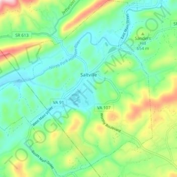
Naam: Topografische kaart Saltville, hoogte, reliëf.
Locatie: Saltville, Smyth County, Virginia, United States (36.84830 -81.80096 36.90559 -81.73622)
Gemiddelde hoogte: 617 m
Minimale hoogte: 507 m
Maximale hoogte: 870 m
Andere topografische kaarten
Klik op een kaart om zijn topografie, zijn hoogte en zijn reliëf te bekijken.
Hungry Mother State Park
United States > Virginia > Smyth County
Hungry Mother State Park, Cabin Fever Drive, Smyth County, Virginia, 24354, United States
Gemiddelde hoogte: 783 m
Sugar Grove
United States > Virginia > Smyth County
Sugar Grove, Smyth County, Virginia, 24375, United States
Gemiddelde hoogte: 952 m
Atkins
United States > Virginia > Smyth County
Atkins, Smyth County, Virginia, 24311, United States
Gemiddelde hoogte: 843 m
Chilhowie
United States > Virginia > Smyth County
Chilhowie, Smyth County, Virginia, United States
Gemiddelde hoogte: 628 m
Groseclose
United States > Virginia > Smyth County > Groseclose
Groseclose, Smyth County, Virginia, 24368, United States
Gemiddelde hoogte: 777 m
Nebo
United States > Virginia > Smyth County > Nebo
Nebo, Smyth County, Virginia, 24318, United States
Gemiddelde hoogte: 771 m
Mount Rogers
United States > Virginia > Smyth County
Mount Rogers, Smyth County, Virginia, United States
Gemiddelde hoogte: 1.507 m