
Topografische kaart Mount Rogers
Interactieve kaart
Klik op de kaart om de hoogte weer te geven.
Over deze kaart
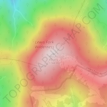
Naam: Topografische kaart Mount Rogers, hoogte, reliëf.
Locatie: Mount Rogers, Smyth County, Virginia, United States (36.65979 -81.54461 36.65989 -81.54451)
Gemiddelde hoogte: 1.507 m
Minimale hoogte: 1.180 m
Maximale hoogte: 1.732 m
Mount Rogers is the highest natural point in Virginia, United States, with a summit elevation of 5,729 feet (1,746 m) above mean sea level. The summit straddles the border of Grayson and Smyth Counties, Virginia, about 6.45 miles (10.38 km) WSW of Troutdale, Virginia. Most of the mountain is contained within the Lewis Fork Wilderness, while the entire area is part of the Mount Rogers National Recreation Area, which itself is a part of the Jefferson National Forest.
Andere topografische kaarten
Klik op een kaart om zijn topografie, zijn hoogte en zijn reliëf te bekijken.
Hungry Mother State Park
United States > Virginia > Smyth County
Hungry Mother State Park, Cabin Fever Drive, Smyth County, Virginia, 24354, United States
Gemiddelde hoogte: 783 m
Sugar Grove
United States > Virginia > Smyth County
Sugar Grove, Smyth County, Virginia, 24375, United States
Gemiddelde hoogte: 952 m
Atkins
United States > Virginia > Smyth County
Atkins, Smyth County, Virginia, 24311, United States
Gemiddelde hoogte: 843 m
Chilhowie
United States > Virginia > Smyth County
Chilhowie, Smyth County, Virginia, United States
Gemiddelde hoogte: 628 m
Groseclose
United States > Virginia > Smyth County > Groseclose
Groseclose, Smyth County, Virginia, 24368, United States
Gemiddelde hoogte: 777 m
Nebo
United States > Virginia > Smyth County > Nebo
Nebo, Smyth County, Virginia, 24318, United States
Gemiddelde hoogte: 771 m
Saltville
United States > Virginia > Smyth County
Saltville, Smyth County, Virginia, United States
Gemiddelde hoogte: 617 m