
Topografische kaart Westport-Belmullet Municipal District
Interactieve kaart
Klik op de kaart om de hoogte weer te geven.
Over deze kaart
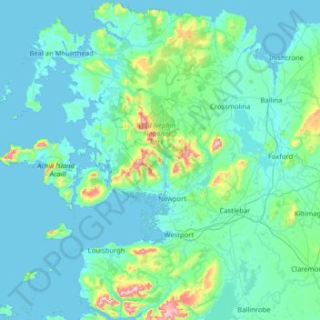
Naam: Topografische kaart Westport-Belmullet Municipal District, hoogte, reliëf.
Gemiddelde hoogte: 62 m
Minimale hoogte: -1 m
Maximale hoogte: 788 m
Andere topografische kaarten
Klik op een kaart om zijn topografie, zijn hoogte en zijn reliëf te bekijken.
Ballina Municipal District
Ballina Municipal District, County Mayo, Connacht, Irland
Gemiddelde hoogte: 74 m