
Topografische kaart Acaill
Interactieve kaart
Klik op de kaart om de hoogte weer te geven.
Over deze kaart
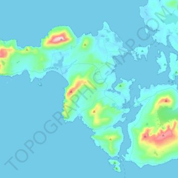
Naam: Topografische kaart Acaill, hoogte, reliëf.
Locatie: Acaill, County Mayo, Connacht, F28X018, Irland (53.87408 -10.25877 54.03020 -9.91432)
Gemiddelde hoogte: 42 m
Minimale hoogte: -2 m
Maximale hoogte: 659 m
Andere topografische kaarten
Klik op een kaart om zijn topografie, zijn hoogte en zijn reliëf te bekijken.
Westport-Belmullet Municipal District
Westport-Belmullet Municipal District, County Mayo, Connacht, Irland
Gemiddelde hoogte: 62 m
Ballina Municipal District
Ballina Municipal District, County Mayo, Connacht, Irland
Gemiddelde hoogte: 74 m