Geolokaliseren

Topografische kaart Marble

Klik op de kaart om de hoogte weer te geven.

👉 Easily get elevation data in JSON, GeoTIFF and KML formats using Elevation API
Bedankt voor het steunen van deze site ❤️
Doe een donatie

Rust jezelf uit voor je volgende avontuur:

Als Amazon-partner verdient deze site een commissie op in aanmerking komende aankopen, zonder extra kosten voor jou.

Over deze kaart

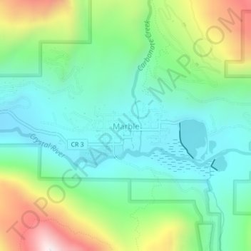
Naam: Topografische kaart Marble, hoogte, reliëf.

Locatie: Marble, Gunnison County, Colorado, United States (39.06769 -107.19962 39.07676 -107.18179)

Gemiddelde hoogte: 2.611 m

Minimale hoogte: 2.391 m

Maximale hoogte: 3.121 m

Andere topografische kaarten

Klik op een kaart om zijn topografie, zijn hoogte en zijn reliëf te bekijken.

Crystal

United States > Colorado > Gunnison County

The elevation of Crystal is centered at 8,950 ft (2,728 m), however the area in and around crystal ranges from 8,500 ft (2,590.8 m) to peaks of 13,500 ft (4,114.8 m). The land is well drained, and the rock types, such as limestone, create very steep slopes, common in the Rocky Mountains. The area is described…

Gemiddelde hoogte: 3.146 m

Abbeyville

United States > Colorado > Gunnison County

Gemiddelde hoogte: 3.144 m

Slide Down

United States > Colorado > Gunnison County

Gemiddelde hoogte: 2.763 m

Crested Butte

United States > Colorado > Gunnison County

At the 2020 United States Census, the town had a total area of 535 acres (2.166 km2), all of it land. Crested Butte lies at an elevation of 8,885 feet (2,708 m) above sea level.

Gemiddelde hoogte: 2.798 m

Monarch Pass

United States > Colorado > Gunnison County

Monarch Pass (elevation 11,312 feet (3,448 m)) is a high mountain pass in central Colorado, in the Rocky Mountains of the western United States.

Gemiddelde hoogte: 3.419 m

Ohio

United States > Colorado > Gunnison County

Gemiddelde hoogte: 2.771 m

Irwin

United States > Colorado > Gunnison County

Gemiddelde hoogte: 3.179 m

Almont

United States > Colorado > Gunnison County

Gemiddelde hoogte: 2.578 m

Taylor River

United States > Colorado > Gunnison County

Gemiddelde hoogte: 3.270 m

Crested Butte

United States > Colorado > Gunnison County

At the 2020 United States census, the town had a total area of 535 acres (2.166 km2), all of it land. Crested Butte lies at an elevation of 8,885 feet (2,708 m) above sea level.

Gemiddelde hoogte: 2.798 m

Bedankt voor het steunen van deze site ❤️
Doe een donatie

Rust jezelf uit voor je volgende avontuur:

Als Amazon-partner verdient deze site een commissie op in aanmerking komende aankopen, zonder extra kosten voor jou.

Gothic

United States > Colorado > Gunnison County

Gemiddelde hoogte: 3.140 m

Mount Baldy

United States > Colorado > Gunnison County

Gemiddelde hoogte: 3.489 m

Rust jezelf uit voor je volgende avontuur:

🪵Aanmaakblokjes - Start veilig een vuur op toegestane plekken
🧗Klimhandschoenen - Voor via ferrata in de Maasvallei
🧵Paracord - Sterk touw voor diverse outdoor toepassingen
🚲Fietssloten - Beveilig je fiets bij een rustpunt
📦Waterdichte Tassen - Bescherming voor elektronica en kaarten

Als Amazon-partner verdient deze site een commissie op in aanmerking komende aankopen, zonder extra kosten voor jou.