
Topografische kaart Almont
Klik op de kaart om de hoogte weer te geven.
Over deze kaart
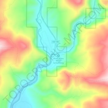
Naam: Topografische kaart Almont, hoogte, reliëf.
Locatie: Almont, Gunnison County, Colorado, United States (38.64471 -106.86615 38.68471 -106.82615)
Gemiddelde hoogte: 2.578 m
Minimale hoogte: 2.431 m
Maximale hoogte: 2.774 m
Andere topografische kaarten
Klik op een kaart om zijn topografie, zijn hoogte en zijn reliëf te bekijken.
Crested Butte
United States > Colorado > Gunnison County
Crested Butte is located in north-central Gunnison County on the west side of the valley of the Slate River, along Coal Creek. Colorado State Highway 135 runs south from Crested Butte 27 miles (43 km) to Gunnison, the county seat. According to the United States Census Bureau, the town of Crested Butte has a…
Gemiddelde hoogte: 2.798 m
Crested Butte
United States > Colorado > Gunnison County
At the 2020 United States Census, the town had a total area of 535 acres (2.166 km2), all of it land. Crested Butte lies at an elevation of 8,885 feet (2,708 m) above sea level.
Gemiddelde hoogte: 2.798 m
Crested Butte
United States > Colorado > Gunnison County
At the 2020 United States census, the town had a total area of 535 acres (2.166 km2), all of it land. Crested Butte lies at an elevation of 8,885 feet (2,708 m) above sea level.
Gemiddelde hoogte: 2.798 m