
Topografische kaart Glady
Interactieve kaart
Klik op de kaart om de hoogte weer te geven.
Over deze kaart
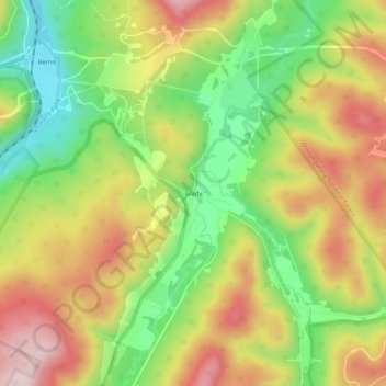
Naam: Topografische kaart Glady, hoogte, reliëf.
Locatie: Glady, Randolph County, West Virginia, 26268, United States (38.77844 -79.73950 38.81844 -79.69950)
Gemiddelde hoogte: 943 m
Minimale hoogte: 776 m
Maximale hoogte: 1.123 m
Andere topografische kaarten
Klik op een kaart om zijn topografie, zijn hoogte en zijn reliëf te bekijken.
Osceola
United States > West Virginia > Randolph County
Osceola, Randolph County, West Virginia, 26296, United States
Gemiddelde hoogte: 1.123 m
Elkins
United States > West Virginia > Randolph County
Elkins, Randolph County, West Virginia, 26241, United States
Gemiddelde hoogte: 637 m
Bemis
United States > West Virginia > Randolph County
Bemis, Randolph County, West Virginia, 26268, United States
Gemiddelde hoogte: 958 m
Montrose
United States > West Virginia > Randolph County
Montrose, Randolph County, West Virginia, United States
Gemiddelde hoogte: 630 m
Whitmer
United States > West Virginia > Randolph County
Whitmer, Randolph County, West Virginia, United States
Gemiddelde hoogte: 972 m
Mill Creek
United States > West Virginia > Randolph County
Mill Creek, Randolph County, West Virginia, United States
Gemiddelde hoogte: 651 m
Adolph
United States > West Virginia > Randolph County
Adolph, Randolph County, West Virginia, 26280, United States
Gemiddelde hoogte: 821 m
Kumbrabow State Forest
United States > West Virginia > Randolph County
Kumbrabow State Forest, Randolph County, West Virginia, United States
Gemiddelde hoogte: 1.013 m
Harman
United States > West Virginia > Randolph County > Harman
Harman, Randolph County, West Virginia, 26760, United States
Gemiddelde hoogte: 814 m
Blue Spring
United States > West Virginia > Randolph County
Blue Spring, Randolph County, West Virginia, 26282, United States
Gemiddelde hoogte: 939 m
White Top
United States > West Virginia > Randolph County
White Top, Randolph County, West Virginia, United States
Gemiddelde hoogte: 1.159 m
Bickle Knob
United States > West Virginia > Randolph County
Bickle Knob, Randolph County, West Virginia, United States
Gemiddelde hoogte: 982 m
Valley Head
United States > West Virginia > Randolph County > Valley Head
Valley Head, Randolph County, West Virginia, 26294, United States
Gemiddelde hoogte: 874 m
Dryfork
United States > West Virginia > Randolph County > Dryfork
Dryfork, Randolph County, West Virginia, 26289, United States
Gemiddelde hoogte: 755 m
Pumpkintown
United States > West Virginia > Randolph County
Pumpkintown, Randolph County, West Virginia, 26278, United States
Gemiddelde hoogte: 743 m