
Topografische kaart White Top
Interactieve kaart
Klik op de kaart om de hoogte weer te geven.
Over deze kaart
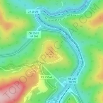
Naam: Topografische kaart White Top, hoogte, reliëf.
Locatie: White Top, Randolph County, West Virginia, United States (38.62451 -79.87678 38.62461 -79.87668)
Gemiddelde hoogte: 1.159 m
Minimale hoogte: 1.072 m
Maximale hoogte: 1.318 m
White Top is a knob and spur of Cheat Mountain in southeastern Randolph County, West Virginia, USA. Sitting at an elevation of 4,085 feet (1,245 m), it is located just west of the Shavers Fork of Cheat River and Cheat Bridge. While White Top was originally crossed by the Staunton–Parkersburg Turnpike, modern-day U.S. Route 250 skirts the base of the knob beside Shavers Fork to the north and east.
Andere topografische kaarten
Klik op een kaart om zijn topografie, zijn hoogte en zijn reliëf te bekijken.
Osceola
United States > West Virginia > Randolph County
Osceola, Randolph County, West Virginia, 26296, United States
Gemiddelde hoogte: 1.123 m
Elkins
United States > West Virginia > Randolph County
Elkins, Randolph County, West Virginia, 26241, United States
Gemiddelde hoogte: 637 m
Bemis
United States > West Virginia > Randolph County
Bemis, Randolph County, West Virginia, 26268, United States
Gemiddelde hoogte: 958 m
Glady
United States > West Virginia > Randolph County
Glady, Randolph County, West Virginia, 26268, United States
Gemiddelde hoogte: 943 m
Montrose
United States > West Virginia > Randolph County
Montrose, Randolph County, West Virginia, United States
Gemiddelde hoogte: 630 m
Whitmer
United States > West Virginia > Randolph County
Whitmer, Randolph County, West Virginia, United States
Gemiddelde hoogte: 972 m
Mill Creek
United States > West Virginia > Randolph County
Mill Creek, Randolph County, West Virginia, United States
Gemiddelde hoogte: 651 m
Adolph
United States > West Virginia > Randolph County
Adolph, Randolph County, West Virginia, 26280, United States
Gemiddelde hoogte: 821 m
Kumbrabow State Forest
United States > West Virginia > Randolph County
Kumbrabow State Forest, Randolph County, West Virginia, United States
Gemiddelde hoogte: 1.013 m
Harman
United States > West Virginia > Randolph County > Harman
Harman, Randolph County, West Virginia, 26760, United States
Gemiddelde hoogte: 814 m
Blue Spring
United States > West Virginia > Randolph County
Blue Spring, Randolph County, West Virginia, 26282, United States
Gemiddelde hoogte: 939 m
Bickle Knob
United States > West Virginia > Randolph County
Bickle Knob, Randolph County, West Virginia, United States
Gemiddelde hoogte: 982 m
Valley Head
United States > West Virginia > Randolph County > Valley Head
Valley Head, Randolph County, West Virginia, 26294, United States
Gemiddelde hoogte: 874 m
Dryfork
United States > West Virginia > Randolph County > Dryfork
Dryfork, Randolph County, West Virginia, 26289, United States
Gemiddelde hoogte: 755 m
Pumpkintown
United States > West Virginia > Randolph County
Pumpkintown, Randolph County, West Virginia, 26278, United States
Gemiddelde hoogte: 743 m