
Topografische kaart Cheviot Hills
Interactieve kaart
Klik op de kaart om de hoogte weer te geven.
Over deze kaart
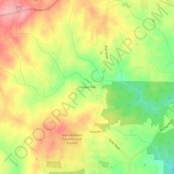
Naam: Topografische kaart Cheviot Hills, hoogte, reliëf.
Locatie: Cheviot Hills, Douglas County, Georgia, United States (33.57733 -84.88577 33.61733 -84.84577)
Gemiddelde hoogte: 325 m
Minimale hoogte: 254 m
Maximale hoogte: 386 m
Andere topografische kaarten
Klik op een kaart om zijn topografie, zijn hoogte en zijn reliëf te bekijken.
Fairplay
United States > Georgia > Douglas County
Fairplay, Douglas County, Georgia, United States
Gemiddelde hoogte: 330 m
Lithia Springs
United States > Georgia > Douglas County
Lithia Springs, Douglas County, Georgia, 30122, United States
Gemiddelde hoogte: 295 m
Shelby Forest
United States > Georgia > Douglas County
Shelby Forest, Douglas County, Georgia, 30135, United States
Gemiddelde hoogte: 309 m
Winston
United States > Georgia > Douglas County
Winston, Douglas County, Georgia, 30187, United States
Gemiddelde hoogte: 340 m
McWhorter
United States > Georgia > Douglas County
McWhorter, Douglas County, Georgia, United States
Gemiddelde hoogte: 308 m
Douglasville
United States > Georgia > Douglas County
Douglasville, Douglas County, Georgia, United States
Gemiddelde hoogte: 310 m
Midway
United States > Georgia > Douglas County > Douglasville > Midway
Midway, Douglasville, Douglas County, Georgia, United States
Gemiddelde hoogte: 328 m
Douglasville Lake Dam
United States > Georgia > Douglas County > Douglasville
Douglasville Lake Dam, Douglasville, Douglas County, Georgia, 30135, United States
Gemiddelde hoogte: 328 m