
Topografische kaart Douglasville
Interactieve kaart
Klik op de kaart om de hoogte weer te geven.
Over deze kaart
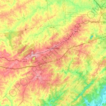
Naam: Topografische kaart Douglasville, hoogte, reliëf.
Locatie: Douglasville, Douglas County, Georgia, United States (33.69597 -84.79482 33.79098 -84.58940)
Gemiddelde hoogte: 310 m
Minimale hoogte: 218 m
Maximale hoogte: 389 m
Located along a natural rise in the topography, Douglasville was originally known as "Skint Chestnut." The name was derived from a large tree used by Native Americans as a landmark; it was stripped of its bark so as to be more conspicuous.
Andere topografische kaarten
Klik op een kaart om zijn topografie, zijn hoogte en zijn reliëf te bekijken.
Fairplay
United States > Georgia > Douglas County
Fairplay, Douglas County, Georgia, United States
Gemiddelde hoogte: 330 m
Lithia Springs
United States > Georgia > Douglas County
Lithia Springs, Douglas County, Georgia, 30122, United States
Gemiddelde hoogte: 295 m
Shelby Forest
United States > Georgia > Douglas County
Shelby Forest, Douglas County, Georgia, 30135, United States
Gemiddelde hoogte: 309 m
Winston
United States > Georgia > Douglas County
Winston, Douglas County, Georgia, 30187, United States
Gemiddelde hoogte: 340 m
Cheviot Hills
United States > Georgia > Douglas County
Cheviot Hills, Douglas County, Georgia, United States
Gemiddelde hoogte: 325 m
McWhorter
United States > Georgia > Douglas County
McWhorter, Douglas County, Georgia, United States
Gemiddelde hoogte: 308 m
Midway
United States > Georgia > Douglas County > Douglasville > Midway
Midway, Douglasville, Douglas County, Georgia, United States
Gemiddelde hoogte: 328 m
Douglasville Lake Dam
United States > Georgia > Douglas County > Douglasville
Douglasville Lake Dam, Douglasville, Douglas County, Georgia, 30135, United States
Gemiddelde hoogte: 328 m