
Topografische kaart Rocky Mountain National Park
Interactieve kaart
Klik op de kaart om de hoogte weer te geven.
Over deze kaart
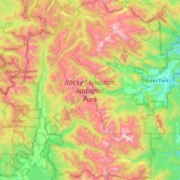
Naam: Topografische kaart Rocky Mountain National Park, hoogte, reliëf.
Gemiddelde hoogte: 3.073 m
Minimale hoogte: 2.248 m
Maximale hoogte: 4.340 m
Rocky Mountain National Park is one of the highest national parks in the nation, with elevations from 7,860 to 14,259 feet (2,396 to 4,346 m), the highest point of which is Longs Peak. Trail Ridge Road is the highest paved through-road in the country, with a peak elevation of 12,183 feet (3,713 m). Sixty mountain peaks over 12,000 feet (3,658 m) high provide scenic vistas. On the north side of the park, the Mummy Range contains a number of thirteener peaks, including Hagues Peak, Mummy Mountain, Fairchild Mountain, Ypsilon Mountain, and Mount Chiquita. Several small glaciers and permanent snowfields are found in the high mountain cirques.
Andere topografische kaarten
Klik op een kaart om zijn topografie, zijn hoogte en zijn reliëf te bekijken.
Cripple Creek
United States of America > Colorado > Cripple Creek
Cripple Creek, Teller County, Colorado, 80081, United States of America
Gemiddelde hoogte: 2.946 m
Candelas
United States of America > Colorado > Arvada > Candelas
Candelas, Arvada, Jefferson County, Colorado, 80007, United States of America
Gemiddelde hoogte: 1.801 m
Pueblo West
United States of America > Colorado
Pueblo West, Pueblo County, Colorado, 81007, United States of America
Gemiddelde hoogte: 1.547 m
Roswell
United States of America > Colorado > Colorado Springs > Roswell
Roswell, Colorado Springs, El Paso County, Colorado, 80907, United States of America
Gemiddelde hoogte: 1.885 m
Green Mountain
United States of America > Colorado > Lakewood
Green Mountain, Lakewood, Jefferson County, Colorado, 80410, United States of America
Gemiddelde hoogte: 1.939 m
Black Forest
United States of America > Colorado > Gleneagle
Black Forest, Tari Court, Gleneagle, El Paso County, Colorado, 80921, United States of America
Gemiddelde hoogte: 2.208 m
Glen Eyrie Reservoir
United States of America > Colorado > Colorado Springs > Roswell
Glen Eyrie Reservoir, Hill Circle, Roswell, Colorado Springs, El Paso County, Colorado, 80904, United States of America
Gemiddelde hoogte: 1.992 m
Crestview
United States of America > Colorado > Crestview
Crestview, Douglas County, Colorado, United States of America
Gemiddelde hoogte: 1.905 m
Gaskil
United States of America > Colorado > Gaskil
Gaskil, Grand County, Colorado, United States of America
Gemiddelde hoogte: 2.790 m
Delta
United States of America > Colorado > Delta
Delta, Delta County, Colorado, 81416, United States of America
Gemiddelde hoogte: 1.550 m
Flat Top Mountain
United States of America > Colorado
Flat Top Mountain, Larimer County, Colorado, United States of America
Gemiddelde hoogte: 3.269 m
Leo Lake
United States of America > Colorado
Leo Lake, 721, El Paso County, Colorado, United States of America
Gemiddelde hoogte: 2.799 m
Midway
United States of America > Colorado > Midway
Midway, El Paso County, Colorado, United States of America
Gemiddelde hoogte: 2.858 m
Rosevale
United States of America > Colorado > Rosevale
Rosevale, Redlands, Mesa County, Colorado, 81502, United States of America
Gemiddelde hoogte: 1.410 m
Corbett Creek
United States of America > Colorado
Corbett Creek, Ouray County, Colorado, 81437, United States of America
Gemiddelde hoogte: 2.931 m
Broomfield
United States of America > Colorado > Broomfield
Broomfield, City and County of Broomfield, Colorado, 80020, United States of America
Gemiddelde hoogte: 1.633 m
Black Canyon
United States of America > Colorado
Black Canyon, Gilpin County, Colorado, United States of America
Gemiddelde hoogte: 2.853 m