
Topografische kaart Bhimtal
Klik op de kaart om de hoogte weer te geven.
Over deze kaart
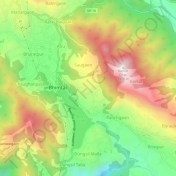
Naam: Topografische kaart Bhimtal, hoogte, reliëf.
Locatie: Bhimtal, Nainital, Uttarakhand, 263136, India (29.31061 79.51417 29.39061 79.59417)
Gemiddelde hoogte: 1.386 m
Minimale hoogte: 634 m
Maximale hoogte: 1.973 m
Andere topografische kaarten
Klik op een kaart om zijn topografie, zijn hoogte en zijn reliëf te bekijken.
Nainital
India > Uttarakhand > Nainital
Nainital is located in the Kumaon foothills of the outer Himalayas at a distance of 276 km (171 mi) from the state capital Dehradun and 314 km (195 mi) from New Delhi, the capital of India. Situated at an altitude of 1,938 metres (6,358 ft) above sea level, the town is set in a valley containing an eye-shaped…
Gemiddelde hoogte: 2.059 m