
Topografische kaart Greater Accra
Interactieve kaart
Klik op de kaart om de hoogte weer te geven.
Over deze kaart
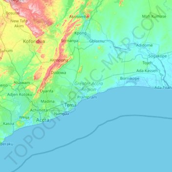
Naam: Topografische kaart Greater Accra, hoogte, reliëf.
Locatie: Greater Accra, Ghana (5.47065 -0.51970 6.10761 0.67226)
Gemiddelde hoogte: 62 m
Minimale hoogte: -5 m
Maximale hoogte: 665 m
Andere topografische kaarten
Klik op een kaart om zijn topografie, zijn hoogte en zijn reliëf te bekijken.
Bonte
Ghana > Bono East Region > Nkoranza North District
Bonte, Nkoranza North District, Bono East Region, Ghana
Gemiddelde hoogte: 335 m
Asokore-Mampong Municipal District
Asokore-Mampong Municipal District, Ashanti (regio), Ghana
Gemiddelde hoogte: 274 m
Accra
Ghana > Greater Accra > Korle-Klottey Municipal District
Accra, Korle-Klottey Municipal District, Greater Accra, Ghana
Gemiddelde hoogte: 31 m
Cape Three Points
Cape Three Points, Western Region, Ghana
Gemiddelde hoogte: 7 m
Sekondi-Takoradi
Ghana > Western Region > Sekondi-Takoradi
Sekondi-Takoradi, Western Region, Ghana
Gemiddelde hoogte: 19 m