
Topografische kaart Down Ampney
Interactieve kaart
Klik op de kaart om de hoogte weer te geven.
Over deze kaart
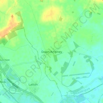
Naam: Topografische kaart Down Ampney, hoogte, reliëf.
Gemiddelde hoogte: 85 m
Minimale hoogte: 76 m
Maximale hoogte: 103 m
Andere topografische kaarten
Klik op een kaart om zijn topografie, zijn hoogte en zijn reliëf te bekijken.
Moreton-in-Marsh
United Kingdom > England > Gloucestershire > Cotswold District
Moreton-in-Marsh, Cotswold District, Gloucestershire, England, United Kingdom
Gemiddelde hoogte: 135 m
Lechlade
United Kingdom > England > Gloucestershire > Cotswold District
Lechlade, Cotswold District, Gloucestershire, England, GL7 3BY, United Kingdom
Gemiddelde hoogte: 81 m
Birdlip
United Kingdom > England > Gloucestershire > Cotswold District
Birdlip, Cotswold District, Gloucestershire, England, GL4 8BN, United Kingdom
Gemiddelde hoogte: 222 m
Broad Campden
United Kingdom > England > Gloucestershire > Cotswold District
Broad Campden, Cotswold District, Gloucestershire, England, GL55 6UU, United Kingdom
Gemiddelde hoogte: 167 m
Fairford
United Kingdom > England > Gloucestershire > Cotswold District > Fairford
Fairford, Cotswold District, Gloucestershire, England, United Kingdom
Gemiddelde hoogte: 98 m
Cirencester
United Kingdom > England > Gloucestershire > Cotswold District > Chesterton
Cirencester, Chesterton, Cotswold District, Gloucestershire, England, United Kingdom
Gemiddelde hoogte: 128 m