
Topografische kaart Kennesaw Mountain
Interactieve kaart
Klik op de kaart om de hoogte weer te geven.
Over deze kaart
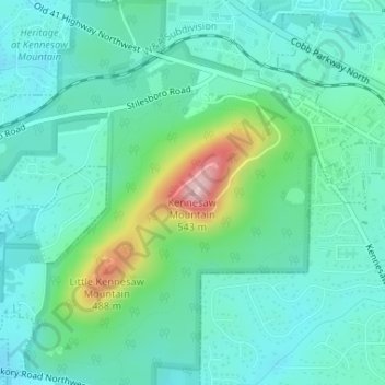
Naam: Topografische kaart Kennesaw Mountain, hoogte, reliëf.
Gemiddelde hoogte: 360 m
Minimale hoogte: 310 m
Maximale hoogte: 532 m
Kennesaw Mountain is a mountain between Marietta and Kennesaw, Georgia in the United States with a summit elevation of 1,808 feet (551 m). It is the highest point in the core (urban and suburban) metro Atlanta area, and fifth after further-north exurban counties are considered. The local terrain averages roughly 1,000 feet (300 m) AMSL.
Andere topografische kaarten
Klik op een kaart om zijn topografie, zijn hoogte en zijn reliëf te bekijken.
Kennesaw
United States > Georgia > Cobb County
Kennesaw, Cobb County, Georgia, 30144, United States
Gemiddelde hoogte: 317 m
Vinings
United States > Georgia > Cobb County
Vinings, Cobb County, Georgia, 30339, United States
Gemiddelde hoogte: 281 m
North Georgia Fairgrounds Lake Dam
United States > Georgia > Cobb County
North Georgia Fairgrounds Lake Dam, Cobb County, Georgia, 30008, United States
Gemiddelde hoogte: 313 m
Lost Mountain Park
United States > Georgia > Cobb County
Lost Mountain Park, Cobb County, Georgia, United States
Gemiddelde hoogte: 343 m
Austell
United States > Georgia > Cobb County
Austell, Cobb County, Georgia, United States
Gemiddelde hoogte: 289 m
Acworth
United States > Georgia > Cobb County
Acworth, Cobb County, Georgia, United States
Gemiddelde hoogte: 281 m
Clarkdale
United States > Georgia > Cobb County
Clarkdale, Cobb County, Georgia, 30111, United States
Gemiddelde hoogte: 281 m
Marietta
United States > Georgia > Cobb County
Marietta, Cobb County, Georgia, United States
Gemiddelde hoogte: 323 m
Smyrna
United States > Georgia > Cobb County
Smyrna, Cobb County, Georgia, United States
Gemiddelde hoogte: 289 m
Fair Oaks
United States > Georgia > Cobb County
Fair Oaks, Cobb County, Georgia, United States
Gemiddelde hoogte: 329 m
Powder Springs
United States > Georgia > Cobb County
Powder Springs, Cobb County, Georgia, United States
Gemiddelde hoogte: 291 m
Mableton
United States > Georgia > Cobb County
Mableton, Cobb County, Georgia, 30126, United States
Gemiddelde hoogte: 298 m
Austell
United States > Georgia > Cobb County > Austell
Austell, Cobb County, Georgia, 30001, United States
Gemiddelde hoogte: 283 m
Kennesaw
United States > Georgia > Cobb County > Kennesaw
Kennesaw, Cobb County, Georgia, 30144, United States
Gemiddelde hoogte: 318 m
Viking Quarry Lake
United States > Georgia > Cobb County
Viking Quarry Lake, Cobb County, Georgia, United States
Gemiddelde hoogte: 303 m
Lost Mountain
United States > Georgia > Cobb County
Lost Mountain, Cobb County, Georgia, United States
Gemiddelde hoogte: 340 m
Marietta
United States > Georgia > Cobb County > Marietta
Marietta, Cobb County, Georgia, 30090, United States
Gemiddelde hoogte: 302 m
Acworth
United States > Georgia > Cobb County > Acworth
Acworth, Cobb County, Georgia, 30101, United States
Gemiddelde hoogte: 280 m
Sweetwater Creek
United States > Georgia > Cobb County > Douglasville
Sweetwater Creek, Douglasville, Cobb County, Georgia, 30122, United States
Gemiddelde hoogte: 287 m