
Topografische kaart Lynchburg
Interactieve kaart
Klik op de kaart om de hoogte weer te geven.
Over deze kaart
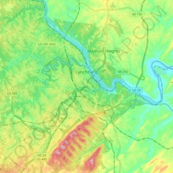
Naam: Topografische kaart Lynchburg, hoogte, reliëf.
Locatie: Lynchburg, Virginia, United States (37.33264 -79.27139 37.46940 -79.08449)
Gemiddelde hoogte: 229 m
Minimale hoogte: 142 m
Maximale hoogte: 404 m
Lynchburg has a four-season humid subtropical climate (Köppen Cfa), with cool winters and hot, humid summers. The monthly daily average temperature ranges from 35.9 °F (2.2 °C) in January to 76.0 °F (24.4 °C) in July. Nights tend to be significantly cooler than days throughout much of the year due in part to the moderate elevation. In a typical year, there are 27.4 days with a high temperature 90 °F (32 °C) or above, and 6.2 days with a high of 32 °F (0 °C) or below. Snowfall averages 11.6 inches (29 cm) per season but this amount varies highly with each winter; the snowiest winter is 1995–96 with 56.8 in (144 cm) of snow, but the following winter recorded only trace amounts, the least on record.
Andere topografische kaarten
Klik op een kaart om zijn topografie, zijn hoogte en zijn reliëf te bekijken.
Blacksburg
United States > Virginia > Montgomery County
Blacksburg, Montgomery County, Virginia, United States
Gemiddelde hoogte: 621 m
Virginia Beach
United States > Virginia > Virginia Beach
Virginia Beach, Virginia, 23451, United States
Gemiddelde hoogte: 2 m
Loudoun County
Loudoun County, Virginia, United States
Gemiddelde hoogte: 150 m
Winchester
Winchester, Virginia, 22601, United States
Gemiddelde hoogte: 226 m
Arlington
United States > Virginia > Arlington County
Arlington, Arlington County, Virginia, United States
Gemiddelde hoogte: 51 m
Crozet
United States > Virginia > Albemarle County > Crozet
Crozet, Albemarle County, Virginia, 23932, United States
Gemiddelde hoogte: 234 m
Christiansburg
United States > Virginia > Montgomery County
Christiansburg, Montgomery County, Virginia, United States
Gemiddelde hoogte: 620 m
Reston
United States > Virginia > Fairfax County
Reston, Fairfax County, Virginia, United States
Gemiddelde hoogte: 110 m
Richmond City
United States > Virginia > Richmond City
Richmond, Richmond City, Virginia, 23298, United States
Gemiddelde hoogte: 53 m
Stafford County
Stafford County, Virginia, United States
Gemiddelde hoogte: 61 m
Fredericksburg
Fredericksburg, Virginia, United States
Gemiddelde hoogte: 38 m
Shenandoah National Park
United States > Virginia > Page County
Shenandoah National Park, Page County, Virginia, United States
Gemiddelde hoogte: 335 m
Albemarle County
Albemarle County, Virginia, United States
Gemiddelde hoogte: 258 m
Charlottesville
Charlottesville, Virginia, United States
Gemiddelde hoogte: 138 m
Chesterfield County
Chesterfield County, Virginia, United States
Gemiddelde hoogte: 63 m
Montgomery County
Montgomery County, Virginia, United States
Gemiddelde hoogte: 657 m
Suffolk
United States > Virginia > Suffolk (city)
Suffolk, Suffolk (city), Virginia, United States
Gemiddelde hoogte: 13 m
Gloucester County
Gloucester County, Virginia, United States
Gemiddelde hoogte: 13 m
Spotsylvania County
Spotsylvania County, Virginia, United States
Gemiddelde hoogte: 87 m
Goochland County
Goochland County, Virginia, United States
Gemiddelde hoogte: 90 m
Roseville
United States > Virginia > Stafford County
Roseville, Stafford County, Virginia, 22556, United States
Gemiddelde hoogte: 86 m
Kempsville Colony
United States > Virginia > Virginia Beach
Kempsville Colony, Virginia Beach, Virginia, 23462, United States
Gemiddelde hoogte: 7 m
Bellwood Meadows
United States > Virginia > Virginia Beach
Bellwood Meadows, Virginia Beach, Virginia, 23453, United States
Gemiddelde hoogte: 6 m
Front Royal
United States > Virginia > Warren County
Front Royal, Warren County, Virginia, United States
Gemiddelde hoogte: 194 m
Frederick County
Frederick County, Virginia, United States
Gemiddelde hoogte: 288 m
Tazewell
United States > Virginia > Tazewell County
Tazewell, Tazewell County, Virginia, United States
Gemiddelde hoogte: 805 m
Ashburn
United States > Virginia > Loudoun County
Ashburn, Loudoun County, Virginia, United States
Gemiddelde hoogte: 85 m
Powhatan County
Powhatan County, Virginia, United States
Gemiddelde hoogte: 87 m
Richardson
United States > Virginia > Mecklenburg County
Richardson, Mecklenburg County, Virginia, United States
Gemiddelde hoogte: 102 m
Culpeper County
Culpeper County, Virginia, United States
Gemiddelde hoogte: 141 m
Fairfax County
Fairfax County, Virginia, United States
Gemiddelde hoogte: 75 m
Tangier Island
United States > Virginia > Accomack County > Tangier
Tangier Island, Tangier, Accomack County, Virginia, 23440, United States
Gemiddelde hoogte: 2 m
Cochran
United States > Virginia > Brunswick County > Alberta
Cochran, Alberta, Brunswick County, Virginia, 23821, United States
Gemiddelde hoogte: 101 m
Kilby
United States > Virginia > Suffolk (city) > Suffolk
Kilby, Suffolk, Suffolk (city), Virginia, 23434, United States
Gemiddelde hoogte: 17 m
Tiptop
United States > Virginia > Tazewell County
Tiptop, Tazewell County, Virginia, United States
Gemiddelde hoogte: 864 m
Montgomery
United States > Virginia > Montgomery County
Montgomery, Montgomery County, Virginia, United States
Gemiddelde hoogte: 584 m
Collinsville
United States > Virginia > Henry County
Collinsville, Henry County, Virginia, 24078, United States
Gemiddelde hoogte: 267 m
Alanton
United States > Virginia > Virginia Beach
Alanton, Virginia Beach, Virginia, 23451, United States
Gemiddelde hoogte: 5 m
Moorings
United States > Virginia > Surry County
Moorings, Surry County, Virginia, 23846, United States
Gemiddelde hoogte: 31 m
Groveton
United States > Virginia > Fairfax County
Groveton, Fairfax County, Virginia, 22036, United States
Gemiddelde hoogte: 40 m
Owensville
United States > Virginia > Albemarle County
Owensville, Albemarle County, Virginia, United States
Gemiddelde hoogte: 173 m
Glasgow
United States > Virginia > Rockbridge County
Glasgow, Rockbridge County, Virginia, United States
Gemiddelde hoogte: 284 m