
Topografische kaart Shenandoah National Park
Interactieve kaart
Klik op de kaart om de hoogte weer te geven.
Over deze kaart
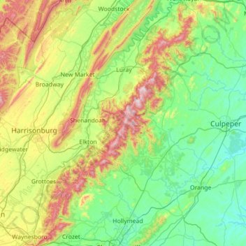
Naam: Topografische kaart Shenandoah National Park, hoogte, reliëf.
Gemiddelde hoogte: 335 m
Minimale hoogte: 72 m
Maximale hoogte: 1.214 m
Shenandoah National Park lies along the Blue Ridge Mountains in north-central Virginia. These mountains form a distinct highland rising to elevations above 4,000 feet (1,200 m). Local topographic relief between the Blue Ridge Mountains and Shenandoah Valley exceeds 3,000 feet (910 m) at some locations. The crest of the range divides the Shenandoah River drainage basin, part of the Potomac River drainage, on the west side, from the James and Rappahannock River drainage basins on the east side.
Andere topografische kaarten
Klik op een kaart om zijn topografie, zijn hoogte en zijn reliëf te bekijken.
Luray
United States > Virginia > Page County
Luray, Page County, Virginia, 22835, United States
Gemiddelde hoogte: 267 m
Grove Hill
United States > Virginia > Page County
Grove Hill, Page County, Virginia, 22849, United States
Gemiddelde hoogte: 293 m
Rileyville
United States > Virginia > Page County
Rileyville, Page County, Virginia, 22650, United States
Gemiddelde hoogte: 242 m
Fairview
United States > Virginia > Page County > Luray
Fairview, Luray, Page County, Virginia, 22835, United States
Gemiddelde hoogte: 283 m
Mauck
United States > Virginia > Page County
Mauck, Page County, Virginia, United States
Gemiddelde hoogte: 468 m
Stanley
United States > Virginia > Page County
Stanley, Page County, Virginia, United States
Gemiddelde hoogte: 328 m
Ingham
United States > Virginia > Page County > Ingham
Ingham, Page County, Virginia, 22849, United States
Gemiddelde hoogte: 361 m
Vaughn
United States > Virginia > Page County > Vaughn
Vaughn, Page County, Virginia, 22650, United States
Gemiddelde hoogte: 304 m