
Topografische kaart Pawne River
Interactieve kaart
Klik op de kaart om de hoogte weer te geven.
Over deze kaart
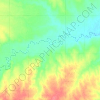
Naam: Topografische kaart Pawne River, hoogte, reliëf.
Gemiddelde hoogte: 725 m
Minimale hoogte: 698 m
Maximale hoogte: 764 m
Andere topografische kaarten
Klik op een kaart om zijn topografie, zijn hoogte en zijn reliëf te bekijken.
Lansing
United States of America > Kansas > Lansing
Lansing, Leavenworth County, Kansas, 66043, United States of America
Gemiddelde hoogte: 266 m
Oakley
United States of America > Kansas > Oakley
Oakley, Logan County, Kansas, 67748, United States of America
Gemiddelde hoogte: 930 m
Earlton
United States of America > Kansas > Earlton
Earlton, Neosho County, Kansas, United States of America
Gemiddelde hoogte: 292 m
Horton
United States of America > Kansas > Horton
Horton, Brown County, Kansas, United States of America
Gemiddelde hoogte: 327 m
Winifred
United States of America > Kansas > Winifred
Winifred, Marshall County, Kansas, United States of America
Gemiddelde hoogte: 378 m
Sawyer
United States of America > Kansas > Sawyer
Sawyer, Pratt County, Kansas, United States of America
Gemiddelde hoogte: 582 m
Norton County
United States of America > Kansas
Norton County, Kansas, United States of America
Gemiddelde hoogte: 719 m
Harvey County
United States of America > Kansas
Harvey County, Kansas, United States of America
Gemiddelde hoogte: 442 m