
Topografische kaart Slieve League
Interactieve kaart
Klik op de kaart om de hoogte weer te geven.
Over deze kaart
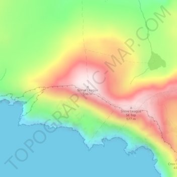
Naam: Topografische kaart Slieve League, hoogte, reliëf.
Gemiddelde hoogte: 233 m
Minimale hoogte: -5 m
Maximale hoogte: 595 m
Andere topografische kaarten
Klik op een kaart om zijn topografie, zijn hoogte en zijn reliëf te bekijken.
Cloncarney
Irland > County Donegal > Letterkenny Municipal District
Cloncarney, Templedouglas ED, Letterkenny Municipal District, County Donegal, Irland
Gemiddelde hoogte: 123 m
Glencolumbkille
Glencolumbkille, County Donegal, Ulster, Irland
Gemiddelde hoogte: 95 m
Glenties Municipal District
Glenties Municipal District, County Donegal, Ulster, Irland
Gemiddelde hoogte: 90 m