
Topografische kaart Glenties Municipal District
Interactieve kaart
Klik op de kaart om de hoogte weer te geven.
Over deze kaart
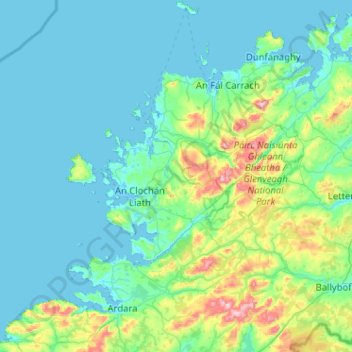
Naam: Topografische kaart Glenties Municipal District, hoogte, reliëf.
Locatie: Glenties Municipal District, County Donegal, Ulster, Irland (54.68883 -8.62103 55.27605 -7.83491)
Gemiddelde hoogte: 90 m
Minimale hoogte: -2 m
Maximale hoogte: 724 m
Andere topografische kaarten
Klik op een kaart om zijn topografie, zijn hoogte en zijn reliëf te bekijken.
Cloncarney
Irland > County Donegal > Letterkenny Municipal District
Cloncarney, Templedouglas ED, Letterkenny Municipal District, County Donegal, Irland
Gemiddelde hoogte: 123 m
Glencolumbkille
Glencolumbkille, County Donegal, Ulster, Irland
Gemiddelde hoogte: 95 m
Slieve League
Slieve League, Donegal Municipal District, County Donegal, Irland
Gemiddelde hoogte: 233 m